IMAGES TAKEN NEAR TO
Chancery Road, ROCHESTER, ME3 7TL
Introduction
This page details the photographs taken nearby to Chancery Road, ME3 7TL by members of the Geograph project.
The Geograph project started in 2005 with the aim of publishing, organising and preserving representative images for every square kilometre of Great Britain, Ireland and the Isle of Man.

There are currently over 7.5m images from over14,400 individuals and you can help contribute to the project by visiting https://www.geograph.org.uk
Image Map
Images are licensed for reuse under creativecommons.org/licenses/by-sa/2.0
Notes
- Clicking on the map will re-center to the selected point.
- The higher the marker number, the further away the image location is from the centre of the postcode.
Image Listing (167 Images Found)
Images are licensed for reuse under creativecommons.org/licenses/by-sa/2.0
Image
Details
Distance
3
Byway and Broken Stench Pipe
This is the byway from Cooling Rd to Chancery Rd Cliffe
Image: © Glyn Baker
Taken: 10 Apr 2008
0.08 miles
7

Quickrills, Church St
An 18th century Grade II listed house. http://www.britishlistedbuildings.co.uk/en-172838-quickrills-cliffe
Image: © N Chadwick
Taken: 29 Jan 2011
0.15 miles
9
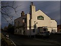
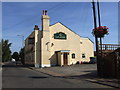
The Evening Star Pub, Cliffe
On 128 Church Street. Beside The Old Police House (130),unseen to the right of the photo.
Image: © David Anstiss
Taken: 18 Jan 2009
0.16 miles