IMAGES TAKEN NEAR TO
West Street, ROCHESTER, ME3 7TH
Introduction
This page details the photographs taken nearby to West Street, ME3 7TH by members of the Geograph project.
The Geograph project started in 2005 with the aim of publishing, organising and preserving representative images for every square kilometre of Great Britain, Ireland and the Isle of Man.

There are currently over 7.5m images from over14,400 individuals and you can help contribute to the project by visiting https://www.geograph.org.uk
Image Map
Images are licensed for reuse under creativecommons.org/licenses/by-sa/2.0
Notes
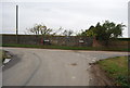
- Clicking on the map will re-center to the selected point.
- The higher the marker number, the further away the image location is from the centre of the postcode.
Image Listing (55 Images Found)
Images are licensed for reuse under creativecommons.org/licenses/by-sa/2.0
Image
Details
Distance
1
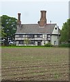
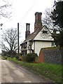
Manor Farm from Buttway Lane
In the past I have struggled to get a satisfactory shot of this building: http://www.geograph.org.uk/photo/2268530 This is a zoom shot taken from a range of a couple of hundred metres.
Image: © Stefan Czapski
Taken: 11 May 2018
0.00 miles
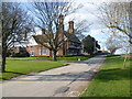
2
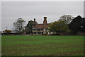
Manor Farm, West Street, Cliffe
In the bare landscape to the west of Cliffe, the Elizabethan house at Manor Farm always grabs the attention.
Image: © Marathon
Taken: 24 Mar 2014
0.01 miles
3
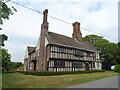
Manor Farmhouse, West Street
Grade II listed.
Image: © JThomas
Taken: 23 Jun 2022
0.01 miles
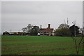
4
Manor Farm, Cliffe (2)
Manor Farm is a working farm, standing on high ground to the west of Cliffe village. This is a view of the Elizabethan farmhouse from the NNE. For another view, see: Image
Image: © Stefan Czapski
Taken: 2 Jan 2011
0.01 miles
5
Manor Farm, West Street, Cliffe
In the bare landscape to the west of Cliffe, the Elizabethan house at Manor Farm with its distinctive brick chimney-stacks always grabs the attention.
Image: © Marathon
Taken: 24 Mar 2014
0.01 miles
6
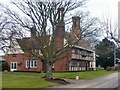
Manor Farm, Cliffe (1)
Manor Farm - still a working farm - stands on high ground to the west of the village. Pevsner describes it as a 'close-studded Elizabethan house, with a continuous overhang, and fine integral brick chimney stacks'. The east-facing frontage is clearly the most original part of the building. For a 16th century timber-framed house, it is by no means small. The great width of the timbered front, the narrowness of the road, and the position of the plane tree made it difficult to get a satisfactory shot - I was anxious to avoid the distortions which arise when shooting 'wide-angle'.
The view here is from the south-east. For another view, see: Image
Image: © Stefan Czapski
Taken: 2 Jan 2011
0.01 miles
7
Manor Farmhouse
Grade II listed. http://www.britishlistedbuildings.co.uk/en-172835-manor-farmhouse-cliffe
Image: © N Chadwick
Taken: 6 Nov 2011
0.04 miles
8
Manor Farmhouse
Grade II listed. http://www.britishlistedbuildings.co.uk/en-172835-manor-farmhouse-cliffe
Image: © N Chadwick
Taken: 6 Nov 2011
0.04 miles
9
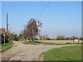
West Street, near Cliffe
This road forms part of National Cycle Network route 179 "The Heron Trail". A blue signpost to the left of the image indicates the cycle route. The route was previously designated as a regional cycle route, numbered 18.
In the distance, cranes of the London Gateway Port are visible on the far side of the River Thames.
Image: © Malc McDonald
Taken: 23 Feb 2019
0.05 miles