IMAGES TAKEN NEAR TO
Rectory Road, ROCHESTER, ME3 7RP
Introduction
This page details the photographs taken nearby to Rectory Road, ME3 7RP by members of the Geograph project.
The Geograph project started in 2005 with the aim of publishing, organising and preserving representative images for every square kilometre of Great Britain, Ireland and the Isle of Man.

There are currently over 7.5m images from over14,400 individuals and you can help contribute to the project by visiting https://www.geograph.org.uk
Image Map
Images are licensed for reuse under creativecommons.org/licenses/by-sa/2.0
Notes
- Clicking on the map will re-center to the selected point.
- The higher the marker number, the further away the image location is from the centre of the postcode.
Image Listing (53 Images Found)
Images are licensed for reuse under creativecommons.org/licenses/by-sa/2.0
Image
Details
Distance
5
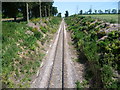
Railway line seen from Buckland Road
Passenger trains ran on this line from 1882 to 1961, which seems surprising now as it doesn't really serve any significant centres of population. It is still in use by regular container trains on their way via Hoo Junction to and from Thamesport on the Isle of Grain.
Image: © Marathon
Taken: 9 Jul 2013
0.09 miles
10
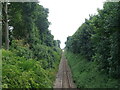
Freight line towards Isle of Grain
From the bridge on Buckland Road.
Image: © JThomas
Taken: 23 Jun 2022
0.10 miles