IMAGES TAKEN NEAR TO
Quickrells Avenue, ROCHESTER, ME3 7RB
Introduction
This page details the photographs taken nearby to Quickrells Avenue, ME3 7RB by members of the Geograph project.
The Geograph project started in 2005 with the aim of publishing, organising and preserving representative images for every square kilometre of Great Britain, Ireland and the Isle of Man.

There are currently over 7.5m images from over14,400 individuals and you can help contribute to the project by visiting https://www.geograph.org.uk
Image Map
Images are licensed for reuse under creativecommons.org/licenses/by-sa/2.0
Notes
- Clicking on the map will re-center to the selected point.
- The higher the marker number, the further away the image location is from the centre of the postcode.
Image Listing (221 Images Found)
Images are licensed for reuse under creativecommons.org/licenses/by-sa/2.0
Image
Details
Distance
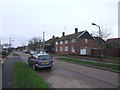
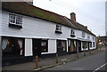
2

Quickrills, Church St
An 18th century Grade II listed house. http://www.britishlistedbuildings.co.uk/en-172838-quickrills-cliffe
Image: © N Chadwick
Taken: 29 Jan 2011
0.07 miles

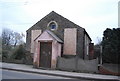
4
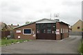
Cliffe fire station
Cliffe fire station, Church Street, Cliffe, Rochester, Kent
Image: © Kevin Hale
Taken: 27 Apr 2009
0.09 miles


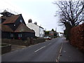
10
An old Hall House
Grade II listed. http://www.britishlistedbuildings.co.uk/en-172846-170-174-cliffe
Image: © N Chadwick
Taken: 6 Nov 2011
0.10 miles