IMAGES TAKEN NEAR TO
Buttway Lane, ROCHESTER, ME3 7QR
Introduction
This page details the photographs taken nearby to Buttway Lane, ME3 7QR by members of the Geograph project.
The Geograph project started in 2005 with the aim of publishing, organising and preserving representative images for every square kilometre of Great Britain, Ireland and the Isle of Man.

There are currently over 7.5m images from over14,400 individuals and you can help contribute to the project by visiting https://www.geograph.org.uk
Image Map
Images are licensed for reuse under creativecommons.org/licenses/by-sa/2.0
Notes
- Clicking on the map will re-center to the selected point.
- The higher the marker number, the further away the image location is from the centre of the postcode.
Image Listing (229 Images Found)
Images are licensed for reuse under creativecommons.org/licenses/by-sa/2.0
Image
Details
Distance
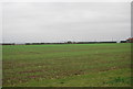
2
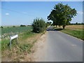
Looking across the fields to St Helen's Church, Cliffe
This is the view from Alleyns Hill Farm with Buttway Lane on the right and St Helen's Church on the skyline.
Image: © Marathon
Taken: 27 Apr 2015
0.03 miles
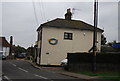
3
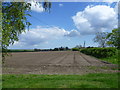
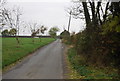
Buttway Lane looking towards Cliffe
This is the view from near Alleyns Hill Farm looking along Buttway Lane towards the village of Cliffe. Cabbages seem to be the main crop around here. There are fine views to the left down to the marshes and the River Thames.
Image: © Marathon
Taken: 3 Sep 2012
0.04 miles
10
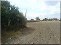
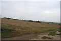
ROC Bunker at Cliffe
The small structure to the left of the picture could easily be missed and is completely invisible from the nearby road. It is in fact the entrance hatch for a Royal Observer Corps nuclear bunker, opened in June 1961 it was closed in 1968 and has remained abandoned since - it's now in poor condition both inside and out - though getting in would be very difficult these days as it has a concrete plug in its entrance. It commands a great view of the Thames estuary and Canvey Island oil refinery.
Image: © Hywel Williams
Taken: 6 Aug 2006
0.09 miles