IMAGES TAKEN NEAR TO
Hermitage Road, ROCHESTER, ME3 7PB
Introduction
This page details the photographs taken nearby to Hermitage Road, ME3 7PB by members of the Geograph project.
The Geograph project started in 2005 with the aim of publishing, organising and preserving representative images for every square kilometre of Great Britain, Ireland and the Isle of Man.

There are currently over 7.5m images from over14,400 individuals and you can help contribute to the project by visiting https://www.geograph.org.uk
Image Map
Images are licensed for reuse under creativecommons.org/licenses/by-sa/2.0
Notes
- Clicking on the map will re-center to the selected point.
- The higher the marker number, the further away the image location is from the centre of the postcode.
Image Listing (9 Images Found)
Images are licensed for reuse under creativecommons.org/licenses/by-sa/2.0
Image
Details
Distance
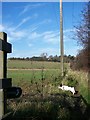
1
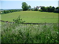
Hillyfield near Higham
This view is from Hermitage Road, looking across horse pastures to the house called Hillyfield. The Medway Estuary can be glimpsed in the distance on the left.
Image: © Marathon
Taken: 6 Jun 2013
0.01 miles
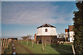
2

Horse pastures next to Hermitage Road
This view looks alongside Hermitage Road (seen on the left here) across horse pastures. The Medway Estuary can be glimpsed in the distance on the right with Cockham Wood at Upnor on its left.
Image: © Marathon
Taken: 6 Jun 2013
0.05 miles
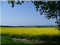
3

View from Hermitage Road
This view from Hermitage Road looks across a field of oilseed rape to the Hoo Peninsula and the Thames Estuary.
Image: © Marathon
Taken: 6 Jun 2013
0.11 miles
5
View from Hermitage Road, Higham
This view from Hermitage Road looks across a field of oilseed rape to the Hoo Peninsula and the Thames Estuary. The footpath leading from here to Higham station can be seen in the middle distance, whilst on the far left is Tilbury Power Station on the other side of the river.
Image: © Marathon
Taken: 6 Jun 2013
0.18 miles
6
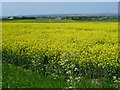
A field of oilseed rape
This view from Hermitage Road looks across a field of oilseed rape to the Hoo Peninsula and the Thames Estuary. The footpath leading from here to Higham station can be seen in the middle distance.
Image: © Marathon
Taken: 6 Jun 2013
0.19 miles
7
Bridleway to Higham Mill
Looking North uphill. Mill unseen on right behind trees.
Leads from Dillywood Lane to Hermitage Road.
Image: © David Anstiss
Taken: 19 Nov 2008
0.21 miles
8
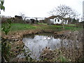
Hermitage Road Duck Pond
This pond on the north side of Hermitage Road, Higham is a favourite of local ducks. For more information about Higham parish please visit...http://www.higham-kent-pc.gov.uk/
Image: © Clive Stanley
Taken: 19 Jan 2006
0.21 miles
9
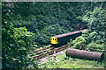
The gap in Higham Tunnel
The original canal tunnel was continuous,but its great length put constraints on the traffic. Accordingly, a passing place was made at a point where there was a slight declivity above, by opening out a quarry from the surface. The canal tunnel was later converted to a rather awkward dual canal and single track railway partly running on the towpath, and then to double track railway only. The old passing place remains as a densely wooded quarry. The tail end of a London-bound train is seen, in 1975.
Image: © Robin Webster
Taken: Unknown
0.24 miles