IMAGES TAKEN NEAR TO
Nuralite Industrial Centre, Canal Road, ROCHESTER, ME3 7JA
Introduction
This page details the photographs taken nearby to Nuralite Industrial Centre, Canal Road, ME3 7JA by members of the Geograph project.
The Geograph project started in 2005 with the aim of publishing, organising and preserving representative images for every square kilometre of Great Britain, Ireland and the Isle of Man.

There are currently over 7.5m images from over14,400 individuals and you can help contribute to the project by visiting https://www.geograph.org.uk
Image Map
Images are licensed for reuse under creativecommons.org/licenses/by-sa/2.0
Notes
- Clicking on the map will re-center to the selected point.
- The higher the marker number, the further away the image location is from the centre of the postcode.
Image Listing (37 Images Found)
Images are licensed for reuse under creativecommons.org/licenses/by-sa/2.0
Image
Details
Distance
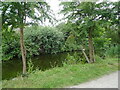
3

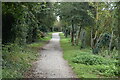
National Cycle Route 1 beside the Thames & Medway Canal
Towards Gravesend.
Image: © JThomas
Taken: 23 Jun 2022
0.04 miles
5
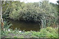
The remains of the Thames & Medway Canal near Higham
This part of the Thames & Medway Canal was opened between Gravesend and Higham in 1801 and continued in use until 1934. This view is just beyond the end of Canal Road and follows the cycle route to Milton and Gravesend which can just be seen through the trees on the right.
Image: © Marathon
Taken: 12 Apr 2011
0.06 miles
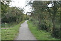
8
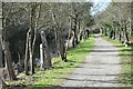
Towpath of the former Thames and Medway Canal
Image: © David Martin
Taken: 17 Feb 2022
0.08 miles
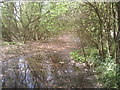
9
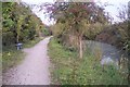
Cyclepath beside the disused Canal
This is part on National Cycle Route 1 leading from Gravesend towards Higham. It follows the tow path of the (disused) Thames and Medway Canal. At this point the Canal (now a long pond) can be seen.
Image: © David Anstiss
Taken: 30 Oct 2009
0.09 miles
10
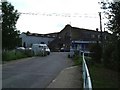
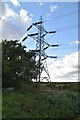
Industrial Units
Marked on the OS map as "works" this factory is now multiple industrial units. Including the manufacturing facility for a Kent based conservatory manufacturer.
Image: © Glyn Baker
Taken: 2 Aug 2005
0.10 miles