IMAGES TAKEN NEAR TO
Isle Of Grain, ROCHESTER, ME3 0AJ
Introduction
This page details the photographs taken nearby to ME3 0AJ by members of the Geograph project.
The Geograph project started in 2005 with the aim of publishing, organising and preserving representative images for every square kilometre of Great Britain, Ireland and the Isle of Man.

There are currently over 7.5m images from over14,400 individuals and you can help contribute to the project by visiting https://www.geograph.org.uk
Image Map
Images are licensed for reuse under creativecommons.org/licenses/by-sa/2.0
Notes
- Clicking on the map will re-center to the selected point.
- The higher the marker number, the further away the image location is from the centre of the postcode.
Image Listing (19 Images Found)
Images are licensed for reuse under creativecommons.org/licenses/by-sa/2.0
Image
Details
Distance
1
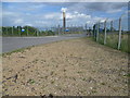
LNG installation
Another view of the construction site for National Grid's liquefied natural gas installation on part of the former Grain oil refinery site.
See also Image
Image: © Richard Dorrell
Taken: 5 Jan 2008
0.09 miles
2
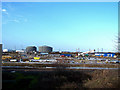
LNG pipeline and storage tanks, Isle of Grain
To quote from the National Grid website - "National Grid Grain LNG Limited, a wholly owned subsidiary of National Grid, has constructed a liquefied natural gas importation and regasification terminal at the Isle of Grain". This photo shows the pipeline (behind a ten foot security fence and inside thick concrete walls...) and two of the new storage tanks.
This is the first installation of its kind in the UK.
Image: © Richard Dorrell
Taken: 5 Jan 2008
0.09 miles
3
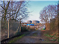
Industrial building site, Isle of Grain
All of this is part of National Grid's liquefied natural gas installation under construction on the site of the former BP oil refinery at Isle of Grain. The storage tanks in the background are not yet shown on OS maps. I think they are in square TQ8675.
Image: © Richard Dorrell
Taken: 5 Jan 2008
0.11 miles
4
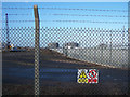
Entrance, Grain LNG
A gas site run by National Grid.
Image: © Robin Webster
Taken: 15 Oct 2016
0.11 miles
5
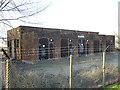
Transformers
Electricity supply transformers beside Grain Road
Image: © Roger W Haworth
Taken: 31 Jan 2007
0.11 miles
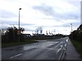
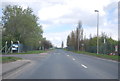
9
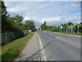
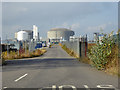
Grain Road
The main road across the Hoo Peninsula is the A228 but after Grain Crossing it becomes the B2001 and only leads to Grain and the site of the former Grain Power Station. Here it passes through an area which until 1982 was home to a major oil refinery. Construction of this facility for British Petroleum (now BP) took from 1948 to 1952. Most of this area is allocated for industrial and warehousing use under the Thames Gateway project and high fences line either side of the road.
Image: © Marathon
Taken: 15 Aug 2013
0.13 miles
10
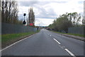
Grain Power Station from Grain Road
The main road across the Hoo Peninsula is the A228 but after Grain Crossing it becomes the B2001 and only leads to Grain and Grain Power Station. Here it passes through an area which until 1982 was home to a major oil refinery. Construction of this facility for British Petroleum (now BP) took from 1948 to 1952. Most of this area is allocated for industrial and warehousing use under the Thames Gateway project and high fences line either side of the road.
Grain Power Station, seen beyond the fence, was an oil-burning power station and was built in the 1970s. It was mothballed in 2003, but reopened in 2006. The chimney seen here is no more as it was blown up on 7th September 2016 - see http://www.kentonline.co.uk/medway/news/chimney-being-blown-up-at-101567/
Image: © Marathon
Taken: 15 Aug 2013
0.18 miles