IMAGES TAKEN NEAR TO
Isle Of Grain, ROCHESTER, ME3 0AB
Introduction
This page details the photographs taken nearby to ME3 0AB by members of the Geograph project.
The Geograph project started in 2005 with the aim of publishing, organising and preserving representative images for every square kilometre of Great Britain, Ireland and the Isle of Man.

There are currently over 7.5m images from over14,400 individuals and you can help contribute to the project by visiting https://www.geograph.org.uk
Image Map
Images are licensed for reuse under creativecommons.org/licenses/by-sa/2.0
Notes
- Clicking on the map will re-center to the selected point.
- The higher the marker number, the further away the image location is from the centre of the postcode.
Image Listing (28 Images Found)
Images are licensed for reuse under creativecommons.org/licenses/by-sa/2.0
Image
Details
Distance
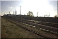
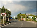
2

Grain Crossing
This level crossing has manually operated gates. Stoke crossing, a mile or so to the west, is automated. The line is freight only. A couple of trains of containers travel to and from nearby Thamesport each day.
Image: © Richard Dorrell
Taken: 22 Dec 2007
0.12 miles
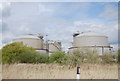
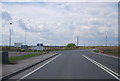
3
Branch line at Grain
On the left are the power station chimneys, on the right the container cranes at Thamesport.
Image: © Robert Eva
Taken: 17 Nov 2018
0.13 miles
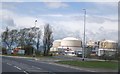
8
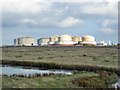
Grain LNG
A gas installation run by National Grid.
Image: © Robin Webster
Taken: 15 Oct 2016
0.14 miles
9
Grain Crossing
Where the A228 meets the B2001.
Image: © Chris Whippet
Taken: 11 Jun 2009
0.14 miles
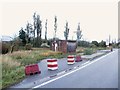
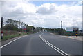
10
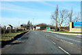
B2001 - Grain crossing ahead
The B2001 crosses the railway on the way off Grain, and immediately becomes the A228, according to some maps. Others have the transition about where the camera is, at the National Grid gas terminal entrance, which makes more sense.
Image: © Robin Webster
Taken: 3 Feb 2019
0.15 miles