IMAGES TAKEN NEAR TO
Upnor Road, ME2 4XL
Introduction
This page details the photographs taken nearby to Upnor Road, ME2 4XL by members of the Geograph project.
The Geograph project started in 2005 with the aim of publishing, organising and preserving representative images for every square kilometre of Great Britain, Ireland and the Isle of Man.

There are currently over 7.5m images from over14,400 individuals and you can help contribute to the project by visiting https://www.geograph.org.uk
Image Map
Images are licensed for reuse under creativecommons.org/licenses/by-sa/2.0
Notes
- Clicking on the map will re-center to the selected point.
- The higher the marker number, the further away the image location is from the centre of the postcode.
Image Listing (244 Images Found)
Images are licensed for reuse under creativecommons.org/licenses/by-sa/2.0
Image
Details
Distance
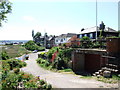
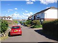
5
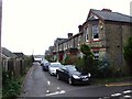
Admiralty Road
This road was formerly known as Powder Monkey Lane. The River Medway can be seen in the distance.
Image: © Robert Edwards
Taken: 1 Apr 2009
0.03 miles
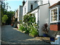
8
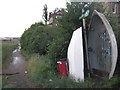
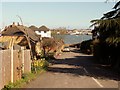
Saxon Shore Way near Upnor
The long distance path leads from Upnor, near Admiralty Terrace, leading along the River Medway towards Strood and Rochester.
Image: © David Anstiss
Taken: 27 Aug 2010
0.04 miles