IMAGES TAKEN NEAR TO
St. Michaels Court, ROCHESTER, ME2 4QZ
Introduction
This page details the photographs taken nearby to St. Michaels Court, ME2 4QZ by members of the Geograph project.
The Geograph project started in 2005 with the aim of publishing, organising and preserving representative images for every square kilometre of Great Britain, Ireland and the Isle of Man.

There are currently over 7.5m images from over14,400 individuals and you can help contribute to the project by visiting https://www.geograph.org.uk
Image Map
Images are licensed for reuse under creativecommons.org/licenses/by-sa/2.0
Notes
- Clicking on the map will re-center to the selected point.
- The higher the marker number, the further away the image location is from the centre of the postcode.
Image Listing (159 Images Found)
Images are licensed for reuse under creativecommons.org/licenses/by-sa/2.0
Image
Details
Distance
2
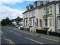
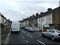
Frindsbury Road, Strood
Near Goddington Road. Showing large 19th century houses and 1930s "suntrap" style houses beyond. This is the A228, the main road out of Strood.
Image: © Danny P Robinson
Taken: 12 Jul 2008
0.03 miles
3
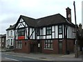
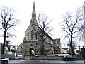
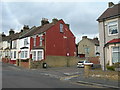
Cobham Inn, Strood
Former pub, now a Chinese Restaurant.
Image: © Chris Whippet
Taken: 22 Mar 2015
0.03 miles
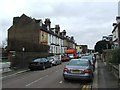
7
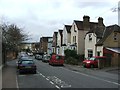
Grove Road, Strood
At the crossroads with Grange Road.
Image: © Danny P Robinson
Taken: 2 Mar 2008
0.06 miles