IMAGES TAKEN NEAR TO
George Summers Close, ROCHESTER, ME2 4NS
Introduction
This page details the photographs taken nearby to George Summers Close, ME2 4NS by members of the Geograph project.
The Geograph project started in 2005 with the aim of publishing, organising and preserving representative images for every square kilometre of Great Britain, Ireland and the Isle of Man.

There are currently over 7.5m images from over14,400 individuals and you can help contribute to the project by visiting https://www.geograph.org.uk
Image Map
Images are licensed for reuse under creativecommons.org/licenses/by-sa/2.0
Notes
- Clicking on the map will re-center to the selected point.
- The higher the marker number, the further away the image location is from the centre of the postcode.
Image Listing (24 Images Found)
Images are licensed for reuse under creativecommons.org/licenses/by-sa/2.0
Image
Details
Distance
1
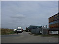
George Summers Close, Medway City Estate
Image: © Chris Whippet
Taken: 10 Sep 2010
0.07 miles
2
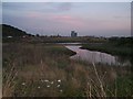
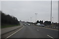
Whitewall Creek, Frindsbury at Dusk
Beside the A289 Vanguard Way. Cars with lights on, coming out of the tunnel from Chatham/Gillingham towards Frindsbury/Grain or M2/A2.
Taken from the McDonald's/Somerfield Garage on Merrick Way. Used by a lot of car drivers to snack before heading on. Therefore a lot of rubbish is thrown over the small fence into creek and marshland.
Image: © David Anstiss
Taken: 19 Nov 2008
0.13 miles
3
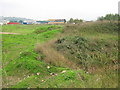
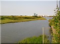
Whitewall Creek Marsh beside Anthony's Way
This section of marshland is between Anthony's Way and the Chatham Reach section of the River Medway. In the background are offices and buildings on George Summers Close, part of Medway City Estate. This section of the marsh, may become a Sainsbury's Supermarket.
Currently, Sainsbury's Supermarket is applying to Medway Council to build a store here and a park and ride development for Chatham.
See http://www.sainsburys-frindsbury.co.uk/parkride.html for more details and plans for the 413 space car park.
Image: © David Anstiss
Taken: 4 Oct 2010
0.15 miles
4
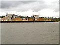
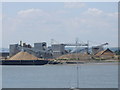
River Medway, Chatham Reach, Aggregates Site,
Looking across the river from the Chatham Dockyard.
Image: © David Dixon
Taken: 14 May 2013
0.16 miles
5
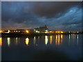
Aggregates Terminal, Medway City Estate (at night)
Looking across the River Medway, at the concrete mixing works as part of the Medway City Estate on a piece of land near Strood.
Image: © David Anstiss
Taken: 29 Oct 2012
0.16 miles
6
Riverside Industrial Panorama, Frindsbury
Looking from Frindsbury towards the River Medway and the industrial area, and towards the former Naval Dockyard at Chatham.
Image: © Danny P Robinson
Taken: 8 Mar 2009
0.17 miles
7
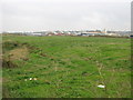
Whitehall Creek Marsh (2)
This section of marshland is between Anthony's Way and the Chatham Reach section of the River Medway. In the background is part of Medway City Estate.
This section of marsh, may become a Sainsbury's Supermarket.
Currently, Sainsbury's Supermarket is applying to Medway Council to build a store here and a park and ride development for Chatham.
See http://www.sainsburys-frindsbury.co.uk/parkride.html for more details and plans for the 413 space car park.
Image: © David Anstiss
Taken: 4 Oct 2010
0.17 miles
10
Whitewall Creek
Looking towards the open Medway. I took this shot from the industrial estate (fairly recently developed) on the south side of the creek.
Image: © Stefan Czapski
Taken: 25 Jul 2012
0.18 miles