IMAGES TAKEN NEAR TO
Ferry Road, ROCHESTER, ME2 1NP
Introduction
This page details the photographs taken nearby to Ferry Road, ME2 1NP by members of the Geograph project.
The Geograph project started in 2005 with the aim of publishing, organising and preserving representative images for every square kilometre of Great Britain, Ireland and the Isle of Man.

There are currently over 7.5m images from over14,400 individuals and you can help contribute to the project by visiting https://www.geograph.org.uk
Image Map
Images are licensed for reuse under creativecommons.org/licenses/by-sa/2.0
Notes
- Clicking on the map will re-center to the selected point.
- The higher the marker number, the further away the image location is from the centre of the postcode.
Image Listing (124 Images Found)
Images are licensed for reuse under creativecommons.org/licenses/by-sa/2.0
Image
Details
Distance
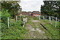
3
Old tramway embankment: Halling
A tramway connected the chalk quarries to the west with the Halling Manor cement plant on the north side of Ferry Road. It crossed Ferry Road on a bridge, the western abutment of which can be seen on the right of the frame. For details, see www.cementkilns.co.uk/cement_kiln_halling_manor.html and related pages.
Image: © Dylan Moore
Taken: 2 Apr 2014
0.03 miles
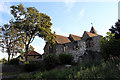
7
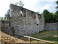
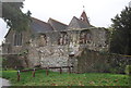
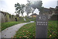
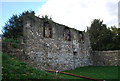
Wall of the former Bishop's Palace at Halling
The Bishop’s Palace was built in 1077 by Bishop Gundulph as a residence for the Bishops of Rochester. Bishop Hamo de Hethe repaired and enlarged the Bishop's Palace between 1322 and 1337. In the 16th century the Bishopric fell into difficulties and was leased to the Dallison family, in whose hands it remained until the 19th century. During this period the Palace started to fall into decline and was being used as a farm until the creation of the Halling Manor Lime and Cement Works in 1871 and the railway that served it. The remains of the railway embankment can still be seen cutting through the centre of the site, adjacent to the medieval Palace walls.
This section of wall, with the churchyard beyond, is the most visible part of the Palace remaining. The whole area has now been landscaped and provides fine views of the River Medway.
Image: © Marathon
Taken: 18 Aug 2013
0.03 miles
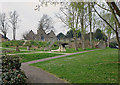
8
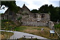
Bishop's Palace ruin and parish church, Halling
Image: © David Martin
Taken: 20 Jul 2013
0.03 miles
9
Remains of Bishop's Palace, Halling, Kent
As seen from Ferry Lane.
Image: © Christine Matthews
Taken: 21 Aug 2011
0.03 miles