Wall of the former Bishop's Palace at Halling
Introduction
The photograph on this page of Wall of the former Bishop's Palace at Halling by Marathon as part of the Geograph project.
The Geograph project started in 2005 with the aim of publishing, organising and preserving representative images for every square kilometre of Great Britain, Ireland and the Isle of Man.

There are currently over 7.5m images from over 14,400 individuals and you can help contribute to the project by visiting https://www.geograph.org.uk
Wall of the former Bishop's Palace at Halling
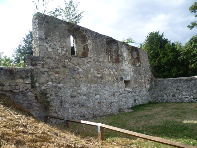
Image: © Marathon Taken: 18 Aug 2013
The Bishop’s Palace was built in 1077 by Bishop Gundulph as a residence for the Bishops of Rochester. Bishop Hamo de Hethe repaired and enlarged the Bishop's Palace between 1322 and 1337. In the 16th century the Bishopric fell into difficulties and was leased to the Dallison family, in whose hands it remained until the 19th century. During this period the Palace started to fall into decline and was being used as a farm until the creation of the Halling Manor Lime and Cement Works in 1871 and the railway that served it. The remains of the railway embankment can still be seen cutting through the centre of the site, adjacent to the medieval Palace walls. This section of wall, with the churchyard beyond, is the most visible part of the Palace remaining. The whole area has now been landscaped and provides fine views of the River Medway.
Images are licensed for reuse under creativecommons.org/licenses/by-sa/2.0
Image Location
Latitude
51.348591
Longitude
0.447497