IMAGES TAKEN NEAR TO
Woodhurst Close, ROCHESTER, ME2 1LU
Introduction
This page details the photographs taken nearby to Woodhurst Close, ME2 1LU by members of the Geograph project.
The Geograph project started in 2005 with the aim of publishing, organising and preserving representative images for every square kilometre of Great Britain, Ireland and the Isle of Man.

There are currently over 7.5m images from over14,400 individuals and you can help contribute to the project by visiting https://www.geograph.org.uk
Image Map
Images are licensed for reuse under creativecommons.org/licenses/by-sa/2.0
Notes
- Clicking on the map will re-center to the selected point.
- The higher the marker number, the further away the image location is from the centre of the postcode.
Image Listing (82 Images Found)
Images are licensed for reuse under creativecommons.org/licenses/by-sa/2.0
Image
Details
Distance
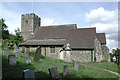
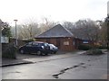
1
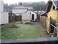
Cuxton Community Church
On Bush Road.
Image: © David Anstiss
Taken: 12 Dec 2008
0.04 miles

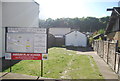
6
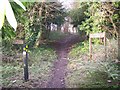
Entrance into Six Acre Community Wood, Cuxton
Near St. Michael's Church, on Church Hill.
Footpath RS209 (going forward) leads to Upper Bush. There are also nature trails around the wood, developed for school children from local schools.
Image: © David Anstiss
Taken: 12 Dec 2008
0.06 miles
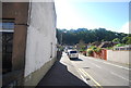
8
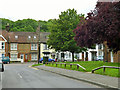
James Road meets Bush Road, Cuxton
The older houses tend to be along Bush Road.
Image: © Robin Webster
Taken: 13 Jun 2012
0.06 miles
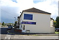
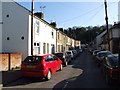
10
Cuxton Library
On Bush Road. Near Cuxton Primary School.
Image: © David Anstiss
Taken: 12 Dec 2008
0.07 miles