IMAGES TAKEN NEAR TO
Poplicans Road, ROCHESTER, ME2 1EH
Introduction
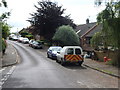
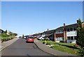
This page details the photographs taken nearby to Poplicans Road, ME2 1EH by members of the Geograph project.
The Geograph project started in 2005 with the aim of publishing, organising and preserving representative images for every square kilometre of Great Britain, Ireland and the Isle of Man.

There are currently over 7.5m images from over14,400 individuals and you can help contribute to the project by visiting https://www.geograph.org.uk
Image Map
Images are licensed for reuse under creativecommons.org/licenses/by-sa/2.0
Notes
- Clicking on the map will re-center to the selected point.
- The higher the marker number, the further away the image location is from the centre of the postcode.
Image Listing (41 Images Found)
Images are licensed for reuse under creativecommons.org/licenses/by-sa/2.0
Image
Details
Distance
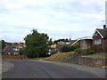
4
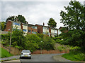
Houses on Charles Drive, Cuxton
Most houses on the residential developments on the steeply sloping downland here are significantly above or below their road, but these are probably the most extreme.
Image: © Robin Webster
Taken: 13 Jun 2012
0.14 miles
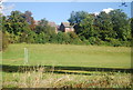
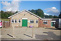
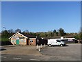
8
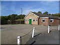
Cuxton Social Club Hall
The facilities include a playing field which can just be seen to the left of the hall beyond the fence.
Image: © Marathon
Taken: 24 Oct 2011
0.17 miles