IMAGES TAKEN NEAR TO
Harold Road, ROCHESTER, ME2 1EE
Introduction
This page details the photographs taken nearby to Harold Road, ME2 1EE by members of the Geograph project.
The Geograph project started in 2005 with the aim of publishing, organising and preserving representative images for every square kilometre of Great Britain, Ireland and the Isle of Man.

There are currently over 7.5m images from over14,400 individuals and you can help contribute to the project by visiting https://www.geograph.org.uk
Image Map
Images are licensed for reuse under creativecommons.org/licenses/by-sa/2.0
Notes
- Clicking on the map will re-center to the selected point.
- The higher the marker number, the further away the image location is from the centre of the postcode.
Image Listing (16 Images Found)
Images are licensed for reuse under creativecommons.org/licenses/by-sa/2.0
Image
Details
Distance
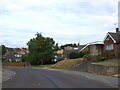
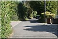
2
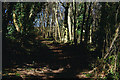
Woodland north of Cuxton
This footpath makes it way up from the A228 near Cuxton village, across the London - Chatham railway, and through this strip of woodland before joining the North Downs Way.
Image: © Stephen McKay
Taken: 28 Mar 2006
0.09 miles
6
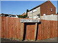
Vintage street nameplate, Hayley Close, Cuxton
Image: © Chris Whippet
Taken: 13 Apr 2014
0.13 miles
10
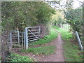
Unused kissing gate and gate on the North Downs Way
The long distance path heads from Mill Hill (near Cuxton) past Longhoes Wood in Ranscombe Farm Nature Reserve heading towards Rochester Road.
Image: © David Anstiss
Taken: 29 Oct 2010
0.20 miles