IMAGES TAKEN NEAR TO
High Street, ROCHESTER, ME2 1DA
Introduction
This page details the photographs taken nearby to High Street, ME2 1DA by members of the Geograph project.
The Geograph project started in 2005 with the aim of publishing, organising and preserving representative images for every square kilometre of Great Britain, Ireland and the Isle of Man.

There are currently over 7.5m images from over14,400 individuals and you can help contribute to the project by visiting https://www.geograph.org.uk
Image Map
Images are licensed for reuse under creativecommons.org/licenses/by-sa/2.0
Notes
- Clicking on the map will re-center to the selected point.
- The higher the marker number, the further away the image location is from the centre of the postcode.
Image Listing (32 Images Found)
Images are licensed for reuse under creativecommons.org/licenses/by-sa/2.0
Image
Details
Distance

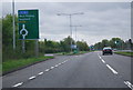
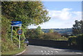
5
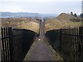
Fenced Footpath
From Meadow Crescent, Upper Halling to A228 Halling By-Pass.
Fences stop vandals or children getting into the quarries either side of the footpath. Quarries belong to Lafarge, but not sure if they are still used.
Roundabout street lighting on A228 seen in background.
Image: © David Anstiss
Taken: 12 Dec 2008
0.08 miles


10
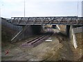
Abandoned railway
Small railway under roundabout on A228. Street lights on left are on the roundabout.
Image: © David Anstiss
Taken: 12 Dec 2008
0.09 miles