IMAGES TAKEN NEAR TO
Rowan Close, AYLESFORD, ME20 7LP
Introduction
This page details the photographs taken nearby to Rowan Close, ME20 7LP by members of the Geograph project.
The Geograph project started in 2005 with the aim of publishing, organising and preserving representative images for every square kilometre of Great Britain, Ireland and the Isle of Man.

There are currently over 7.5m images from over14,400 individuals and you can help contribute to the project by visiting https://www.geograph.org.uk
Image Map
Images are licensed for reuse under creativecommons.org/licenses/by-sa/2.0
Notes
- Clicking on the map will re-center to the selected point.
- The higher the marker number, the further away the image location is from the centre of the postcode.
Image Listing (129 Images Found)
Images are licensed for reuse under creativecommons.org/licenses/by-sa/2.0
Image
Details
Distance
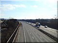
5
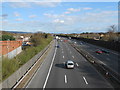
M20 near Aylesford
Looking coastbound. To the left there is an electricity substation. The chimney almost centre-shot is the incinerator at Allington.
Image: © Danny P Robinson
Taken: 18 Mar 2014
0.08 miles
10
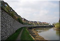
Bend in the River Medway
The Friars View riverside development can be seen in the photo.
Image: © N Chadwick
Taken: 15 Apr 2010
0.12 miles