IMAGES TAKEN NEAR TO
Robson Drive, AYLESFORD, ME20 7JR
Introduction
This page details the photographs taken nearby to Robson Drive, ME20 7JR by members of the Geograph project.
The Geograph project started in 2005 with the aim of publishing, organising and preserving representative images for every square kilometre of Great Britain, Ireland and the Isle of Man.

There are currently over 7.5m images from over14,400 individuals and you can help contribute to the project by visiting https://www.geograph.org.uk
Image Map
Images are licensed for reuse under creativecommons.org/licenses/by-sa/2.0
Notes
- Clicking on the map will re-center to the selected point.
- The higher the marker number, the further away the image location is from the centre of the postcode.
Image Listing (106 Images Found)
Images are licensed for reuse under creativecommons.org/licenses/by-sa/2.0
Image
Details
Distance
4
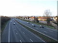
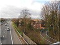
M20, Aylesford, Kent
view E from the Station Road bridge.
Image: © Rodney Burton
Taken: 23 Jun 2006
0.06 miles
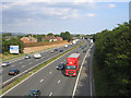
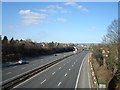
5
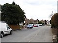
M20 and Houses on Station Road, Aylesford
The carriageway to the left is London-bound, traffic coming towards us is coast-bound. The M20 passes within a few metres of the houses on Station Road, and may well have been built on what was originally the back gardens of these houses.
Image: © Danny P Robinson
Taken: 18 Mar 2014
0.07 miles

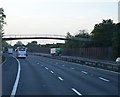
9
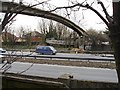
Footbridge on Teapot Lane
Giving pedestrian access across the M20 motorway to Aylesford Station at the point where the newer road cut through the old.
Image: © Penny Mayes
Taken: 6 Mar 2006
0.07 miles
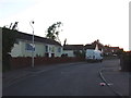
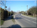
10
Teapot Lane, Ditton
Looking south. About 40 years ago a through route to Station Road, Aylesford but now a dead end, cut off by the M20 motorway and culminating in a footbridge http://www.geograph.org.uk/photo/133854
Image: © Penny Mayes
Taken: 6 Mar 2006
0.07 miles