IMAGES TAKEN NEAR TO
Chatham Road, AYLESFORD, ME20 7EE
Introduction
This page details the photographs taken nearby to Chatham Road, ME20 7EE by members of the Geograph project.
The Geograph project started in 2005 with the aim of publishing, organising and preserving representative images for every square kilometre of Great Britain, Ireland and the Isle of Man.

There are currently over 7.5m images from over14,400 individuals and you can help contribute to the project by visiting https://www.geograph.org.uk
Image Map
Images are licensed for reuse under creativecommons.org/licenses/by-sa/2.0
Notes
- Clicking on the map will re-center to the selected point.
- The higher the marker number, the further away the image location is from the centre of the postcode.
Image Listing (35 Images Found)
Images are licensed for reuse under creativecommons.org/licenses/by-sa/2.0
Image
Details
Distance
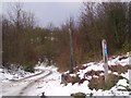
1

Marker post on Route 17 of the National Cycle Network
Hidden away behind the service station on the southbound A229 this extraordinary signpost has a beautiful bas-relief of the archaeology of the underlying rock.
Image: © Andy Potter
Taken: 31 Aug 2008
0.03 miles
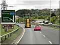
2
North Downs Way near Esso Petrol Garage on the A229
The long distance path heads down a bridleway (with National Cycle Route 17) to head under the A229 Dual Carriageway.
Image: © David Anstiss
Taken: 24 Dec 2009
0.04 miles


8
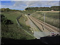
Eurolink railway track SE of Kit's Coty Village
Image: © Colin Park
Taken: 20 Oct 2014
0.08 miles
9
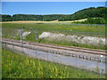
Channel Tunnel Rail Link at Blue Bell Hill
The area around the Channel Tunnel Rail Link where it enters the North Downs Tunnel is a sea of wild flowers in summer, including orchids. Beyond on the left is Frith Wood and on the right is Westfield Wood covering the slopes of the North Downs.
Image: © Marathon
Taken: 23 Jul 2012
0.10 miles
10
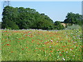
Wild flowers near the North Downs Way
Just after crossing the Channel Tunnel Rail Link near the North Downs Tunnel, this sea of wild flowers can be seen on the edge of a field. Poppies and scabious are particularly in evidence.
Image: © Marathon
Taken: 23 Jul 2012
0.10 miles