IMAGES TAKEN NEAR TO
St. Marys Court, Church Fields, WEST MALLING, ME19 6RQ
Introduction
This page details the photographs taken nearby to St. Marys Court, Church Fields, ME19 6RQ by members of the Geograph project.
The Geograph project started in 2005 with the aim of publishing, organising and preserving representative images for every square kilometre of Great Britain, Ireland and the Isle of Man.

There are currently over 7.5m images from over14,400 individuals and you can help contribute to the project by visiting https://www.geograph.org.uk
Image Map
Images are licensed for reuse under creativecommons.org/licenses/by-sa/2.0
Notes
- Clicking on the map will re-center to the selected point.
- The higher the marker number, the further away the image location is from the centre of the postcode.
Image Listing (102 Images Found)
Images are licensed for reuse under creativecommons.org/licenses/by-sa/2.0
Image
Details
Distance

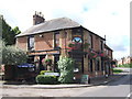
3
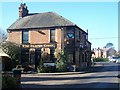
Sacred Crow Public House, West Malling
On junction of 71 West Malling Road (on right) and Churchfields (in front).
Image: © David Anstiss
Taken: 2 Mar 2009
0.06 miles


10
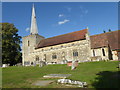
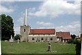
St Mary's Church, West Malling
St Mary's Church in West Malling is at the south end of High Street, just as it turns towards Manor Park Country Park.
There is early Norman evidence in the chancel and a genuine 13th century north doorway. The church was also lengthened in the 13th century. The tower also had early Norman evidence but the spire only dates from 1837. The nave was rebuilt in the 1780s and again at the start of the 20th century.
See also https://www.geograph.org.uk/photo/5974006
Image: © Marathon
Taken: 11 Oct 2018
0.10 miles