IMAGES TAKEN NEAR TO
Lavenders Road, WEST MALLING, ME19 6HP
Introduction
This page details the photographs taken nearby to Lavenders Road, ME19 6HP by members of the Geograph project.
The Geograph project started in 2005 with the aim of publishing, organising and preserving representative images for every square kilometre of Great Britain, Ireland and the Isle of Man.

There are currently over 7.5m images from over14,400 individuals and you can help contribute to the project by visiting https://www.geograph.org.uk
Image Map
Images are licensed for reuse under creativecommons.org/licenses/by-sa/2.0
Notes
- Clicking on the map will re-center to the selected point.
- The higher the marker number, the further away the image location is from the centre of the postcode.
Image Listing (39 Images Found)
Images are licensed for reuse under creativecommons.org/licenses/by-sa/2.0
Image
Details
Distance
1
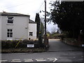
Lavenders Care Home, Lavender Road, West Malling
The care home was established in 1982 and is at the junction of Lavenders Road and Water Lane.
Image: © PAUL FARMER
Taken: 13 Mar 2010
0.05 miles
2
Manor Park Country Park
Manor House is conspicuous to the west of St Leonard's Street to the south of West Malling. In origin it is early 18th century but what one sees is now all from c.1840. The park and lake is now to the east of St Leonard's Street and provides a very attractive country park. The stream is the Ewell Stream, the widening of which in the 18th century, created the lake. The Ewell Stream is here seen from the outflow of the lake and will enter Leybourne Lakes in due course.
Image: © Marathon
Taken: 11 Oct 2018
0.10 miles
3
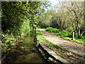
Path to West Malling
This path leads from the lake within the park along a stream towards West Malling and Ewell Monastery via Water Lane.
Image: © David Anstiss
Taken: 26 Jan 2012
0.12 miles
4
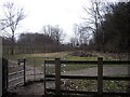
Kissing gate at Manor Park Country Park, West Malling
The gate is at the boundary of the park and Water Lane. The park was once part of the landscaped grounds of Douces Manor.
Image: © PAUL FARMER
Taken: 13 Mar 2010
0.12 miles
5
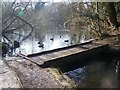
Footbridge in Manor Park Country Park
Stream from West Malling widens out to make a lake. The bridge crossing it, leads from car park footpath in park to St.Leonard's Street.
Image: © David Anstiss
Taken: 27 Jan 2009
0.13 miles
6
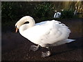
Mute Swan in Manor Park Country Park
This large male swan was greeting visitors in the country park. His partner is in the lake in the background.
Image: © David Anstiss
Taken: 26 Jan 2012
0.14 miles
7
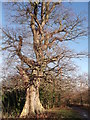
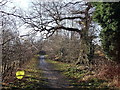
Path and ancient tree in Manor Park Country Park
This path leads from Douce's Meadow around Abbey Field (on the right/beyond the hedge) towards Water Lane.
Unsure if the tree is an oak or beech.
Image: © David Anstiss
Taken: 26 Jan 2012
0.14 miles
9
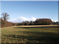
Abbey Field, Manor Park Country Park
Abbey Field is a large field (to the west of the estate) used mainly for grazing cattle during various parts of the year, helping promote further wildlife and plant life diversity within the park.
A grass path leads to Water Lane.
Image: © David Anstiss
Taken: 26 Jan 2012
0.15 miles
10
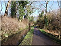
Path in Manor Park Country Park
This path leads from Water Lane around Abbey Field (on the left/beyond the hedge) towards Douce's Meadow.
Image: © David Anstiss
Taken: 26 Jan 2012
0.15 miles