IMAGES TAKEN NEAR TO
Park Farm Road, WEST MALLING, ME19 5JX
Introduction
This page details the photographs taken nearby to Park Farm Road, ME19 5JX by members of the Geograph project.
The Geograph project started in 2005 with the aim of publishing, organising and preserving representative images for every square kilometre of Great Britain, Ireland and the Isle of Man.

There are currently over 7.5m images from over14,400 individuals and you can help contribute to the project by visiting https://www.geograph.org.uk
Image Map
Images are licensed for reuse under creativecommons.org/licenses/by-sa/2.0
Notes
- Clicking on the map will re-center to the selected point.
- The higher the marker number, the further away the image location is from the centre of the postcode.
Image Listing (13 Images Found)
Images are licensed for reuse under creativecommons.org/licenses/by-sa/2.0
Image
Details
Distance
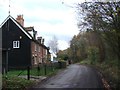
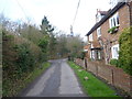
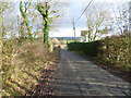
2
Park Farm Road near Ryarsh
This is a small hamlet away from the village of Ryarsh. Park Farm Road is ahead, while Workhouse Road is behind and Chapel Street is to the right. The footpath through Ryarsh Wood is just beyond the 'no through road' sign.
Image: © Marathon
Taken: 20 Dec 2014
0.02 miles
3
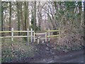
The Coldrum Trail enters Ryarsh Wood
The Trosley Country Park,a circular walk enters woodland via stile on Workhorse Road, and leads to Coldrum Lane.
Image: © David Anstiss
Taken: 10 Feb 2009
0.03 miles
5
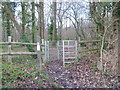
Entrance to Ryarsh Wood
The path is seen from a small hamlet away from the village of Ryarsh. It eventually after a muddy trek emerges near Coldrum Long Barrow.
Image: © Marathon
Taken: 20 Dec 2014
0.04 miles
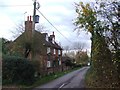
6
Chapel Lane near Ryarsh
This is a small hamlet away from the village of Ryarsh. Park Farm Road is ahead beyond the junction where Workhouse Road joins from the left. A footpath through Ryarsh Wood is just beyond the 'no through road' sign.
Image: © Marathon
Taken: 20 Dec 2014
0.04 miles
7
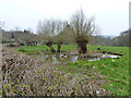
Duckpond, Ryarsh
Over the hedge from Chapel Street.
Image: © Robin Webster
Taken: 29 Mar 2011
0.09 miles
8
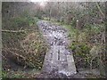
Footbridge in Ryarsh Wood
The Trosley Country Park - circular walk, leads over bridge to Workhouse Road, Ryarsh, from Coldrum lane.
Image: © David Anstiss
Taken: 10 Feb 2009
0.16 miles
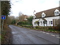
10
Chapel Street near Ryarsh
Chapel Street leads to the village of Ryarsh just ahead. This is near Cleggett's Farm.
Image: © Marathon
Taken: 20 Dec 2014
0.19 miles