IMAGES TAKEN NEAR TO
Yates Gardens, WEST MALLING, ME19 5FP
Introduction
This page details the photographs taken nearby to Yates Gardens, ME19 5FP by members of the Geograph project.
The Geograph project started in 2005 with the aim of publishing, organising and preserving representative images for every square kilometre of Great Britain, Ireland and the Isle of Man.

There are currently over 7.5m images from over14,400 individuals and you can help contribute to the project by visiting https://www.geograph.org.uk
Image Map
Images are licensed for reuse under creativecommons.org/licenses/by-sa/2.0
Notes
- Clicking on the map will re-center to the selected point.
- The higher the marker number, the further away the image location is from the centre of the postcode.
Image Listing (11 Images Found)
Images are licensed for reuse under creativecommons.org/licenses/by-sa/2.0
Image
Details
Distance
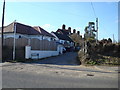
2
The Wheatsheaf Pub, West Malling
On A20 London Road, also has B+B accommodation.
Image: © David Anstiss
Taken: 27 Jan 2009
0.09 miles
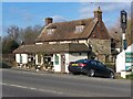
3
The Wheatsheaf public house, West Malling
Image: © Stacey Harris
Taken: 7 Mar 2010
0.10 miles
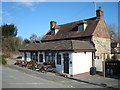
6
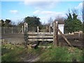
Level Crossing near West Malling
Footpath leads from Ryarsh Lane (near Station carpark) to A20 London Road, near Wheatsheaf Pub. Railway heads left to Borough Green from West Malling.
Image: © David Anstiss
Taken: 27 Jan 2009
0.16 miles
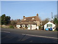
7
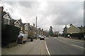
Houses on London Road
The A20 towards Wrotham Heath.
Image: © Oast House Archive
Taken: 26 Mar 2010
0.19 miles
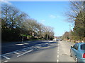
10
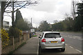
London Road
A20 towards Maidstone.
Image: © Oast House Archive
Taken: 26 Mar 2010
0.25 miles