IMAGES TAKEN NEAR TO
Pilgrims Way, WEST MALLING, ME19 5EW
Introduction
This page details the photographs taken nearby to Pilgrims Way, ME19 5EW by members of the Geograph project.
The Geograph project started in 2005 with the aim of publishing, organising and preserving representative images for every square kilometre of Great Britain, Ireland and the Isle of Man.

There are currently over 7.5m images from over14,400 individuals and you can help contribute to the project by visiting https://www.geograph.org.uk
Image Map
Images are licensed for reuse under creativecommons.org/licenses/by-sa/2.0
Notes
- Clicking on the map will re-center to the selected point.
- The higher the marker number, the further away the image location is from the centre of the postcode.
Image Listing (30 Images Found)
Images are licensed for reuse under creativecommons.org/licenses/by-sa/2.0
Image
Details
Distance
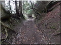
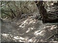
2
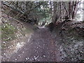
Sunken lane on the North Downs
With its high banks, this is clearly an old trackway. It is now followed by both the Wealdway and the North Downs Way leading from the summit of the scarp slope behind to the Pilgrim's Way at the foot of the North Downs ahead. On this day the strong winds through the trees made it feel like something out of the Lord of the Rings.
Image: © Marathon
Taken: 2 Mar 2019
0.13 miles
3
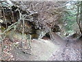
Fallen trees alongside the North Downs Way
The North Downs Way here heads down from the crest of the Downs to meet the Pilgrim's Way at the foot of the hill. Alongside a number of beech trees have been left where they fell in the October 1987 Storm, or one of the subsequent storms. The wind would have come in from the west and caught them at this exposed spot where possibly erosion at their roots did not help their stability.
Image: © Marathon
Taken: 20 Dec 2014
0.14 miles
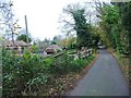
5
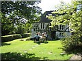
Afternoon tea at the junction of the Wealdway and North Downs Way
For two days each year this eighteenth century house with its beautiful garden and views plays host to all comers, providing cream teas and memorable cakes in aid of charity.
Image: © Pip Rolls
Taken: 28 Aug 2006
0.14 miles
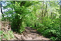
6
Sunken lane on the North Downs
With its high banks, this is clearly an old trackway. It is now followed by both the Wealdway and the North Downs Way leading up from the Pilgrim's Way at the foot of the North Downs to the summit of the scarp slope a little way ahead. On this day the strong winds through the trees made it feel like something out of the Lord of the Rings.
Image: © Marathon
Taken: 2 Mar 2019
0.14 miles
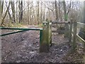
7
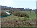
Downland, Trosley Country Park
The fence on the left surrounds an old quarry.
Image: © Robin Webster
Taken: 29 Mar 2011
0.15 miles
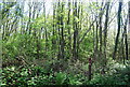
9
North Downs Way leaves Trosley Country Park
The long distance path goes downhill in Great Wood leading to the Pilgrim's Way.
The bridlepath heading left leads to Crommority Road.
Image: © David Anstiss
Taken: 10 Feb 2009
0.16 miles
10
Sunken lane on the North Downs
With its high banks, this is clearly an old trackway. It is now followed by both the Wealdway and the North Downs Way leading up from the Pilgrim's Way at the foot of the North Downs to the summit of the scarp slope a little way ahead. On this day the strong winds through the trees made it feel like something out of the Lord of the Rings.
Image: © Marathon
Taken: 9 May 2021
0.16 miles