IMAGES TAKEN NEAR TO
London Road, WEST MALLING, ME19 5DB
Introduction
This page details the photographs taken nearby to London Road, ME19 5DB by members of the Geograph project.
The Geograph project started in 2005 with the aim of publishing, organising and preserving representative images for every square kilometre of Great Britain, Ireland and the Isle of Man.

There are currently over 7.5m images from over14,400 individuals and you can help contribute to the project by visiting https://www.geograph.org.uk
Image Map
Images are licensed for reuse under creativecommons.org/licenses/by-sa/2.0
Notes
- Clicking on the map will re-center to the selected point.
- The higher the marker number, the further away the image location is from the centre of the postcode.
Image Listing (19 Images Found)
Images are licensed for reuse under creativecommons.org/licenses/by-sa/2.0
Image
Details
Distance
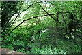
1
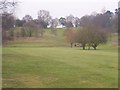
West Malling Golf Course
As seen from footpath from St Vincents Lane to A20 London Road.
Path is not very well marked. Also comes out onto road, through untrimmed hedge, difficult to see gap in trees on the golf course.
Image: © David Anstiss
Taken: 17 Feb 2009
0.07 miles
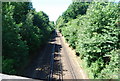
4
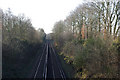
Railway near Wrotham Heath
Looking west from Aldon Lane bridge.
Image: © Robin Webster
Taken: 3 Feb 2007
0.16 miles
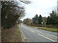
5

Car dealer, London Road, Wrotham Heath
Image: © Stacey Harris
Taken: 13 Mar 2010
0.18 miles
6
Railway line looking west
Taken from Aldon Lane Bridge.
Image: © N Chadwick
Taken: 10 Jul 2010
0.18 miles
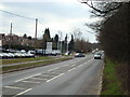
7
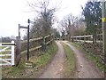
Footpath on Aldon Lane
Path No.Mr175 leads past Mount Cottage, leads past horse paddocks on Shaws Hill, then goes through a private garden to reach A20 London Road.
Image: © David Anstiss
Taken: 17 Feb 2009
0.20 miles
8
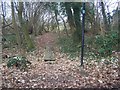
Footbridge in small woods near St Vincents Lane
Footpath No.MR173 goes through woods and then across golf course to reach the A20 London Road. Stream currently dry but ready for storm waters.
Image: © David Anstiss
Taken: 17 Feb 2009
0.20 miles
10
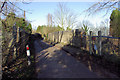
Railway Bridge, Aldon Lane
Leading up to the A20 near Wrotham Heath.
Image: © Robin Webster
Taken: 3 Feb 2007
0.22 miles