IMAGES TAKEN NEAR TO
Progress Road, WEST MALLING, ME19 4XY
Introduction
This page details the photographs taken nearby to Progress Road, ME19 4XY by members of the Geograph project.
The Geograph project started in 2005 with the aim of publishing, organising and preserving representative images for every square kilometre of Great Britain, Ireland and the Isle of Man.

There are currently over 7.5m images from over14,400 individuals and you can help contribute to the project by visiting https://www.geograph.org.uk
Image Map
Images are licensed for reuse under creativecommons.org/licenses/by-sa/2.0
Notes
- Clicking on the map will re-center to the selected point.
- The higher the marker number, the further away the image location is from the centre of the postcode.
Image Listing (14 Images Found)
Images are licensed for reuse under creativecommons.org/licenses/by-sa/2.0
Image
Details
Distance
1
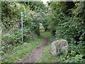
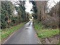
Bridleway off Teston Road
This is the view from Teston Road, just beyond St Leonard's Street which is the southern extension of West Malling. Teston Road must have once been a through route before the A228 (Ashton Way) cut across it to by-pass West Malling. The bridleway here veers off to also meet the A228.
Image: © Marathon
Taken: 13 Oct 2015
0.12 miles
2
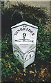
Old Milestone by King Hill, West Malling
Metal plate attached to stone post by the UC road (was A228), in parish of WEST MALLING (TONBRIDGE AND MALLING District), King Hill, 300m North of roundabout on West Malling by-pass, between pavement and front garden, on East side of road. Kent hipped iron plate (Ransomes), erected by the Wrotham & Maidstone turnpike trust in the 19th century.
Inscription reads:-
: MEREWORTH / 2 : : TO / TONBRIDGE / 9 / M / - / West Malling : : WEST MALLING / 1 :
Maker:-
: RANSOME / IPSWICH. :
Kent HER listed.
HER Number: TQ 65 NE 383 https://www.heritagegateway.org.uk/Gateway/Results_Single.aspx?uid=MKE78205&resourceID=1005
Milestone Society National ID: KE_WMTB01.
Image: © C Woodward
Taken: 24 Jun 2008
0.13 miles
3
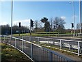
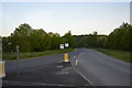
Roundabout on A228 Ashton Way
The West Malling by-pass (on right), reaches this junction. Then Tower View turns left into Kings Hill. Ashton Way goes straight on to Tonbridge.
Image: © David Anstiss
Taken: 27 Jan 2009
0.15 miles
4
West Malling Kings Hill bus stop
On the old route through the village, just before the southern end of the bypass.
Image: © Robin Webster
Taken: 9 Jun 2012
0.16 miles
6
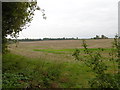
Fields near West Malling
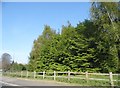
This is the view from Teston Road, just beyond St Leonard's Street which is the southern extension of West Malling. Teston Road must have once been a through route before the A228 (Ashton Way) cut across it to by-pass West Malling.
Image: © Marathon
Taken: 13 Oct 2015
0.17 miles
7
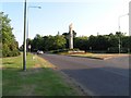
Entrance to Kings Hill Industrial Estate and village
The entrance to Kings Hill industrial estate. The location has two entrances, both have interesting sculptures and landscapes.
Image: © Hywel Williams
Taken: 2 Aug 2005
0.18 miles
8
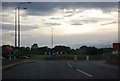
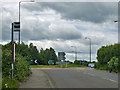
Roundabout at the end of the West Malling bypass
Image: © N Chadwick
Taken: 14 May 2011
0.19 miles