IMAGES TAKEN NEAR TO
Warwick Way, ME19 4UJ
Introduction
This page details the photographs taken nearby to Warwick Way, ME19 4UJ by members of the Geograph project.
The Geograph project started in 2005 with the aim of publishing, organising and preserving representative images for every square kilometre of Great Britain, Ireland and the Isle of Man.

There are currently over 7.5m images from over14,400 individuals and you can help contribute to the project by visiting https://www.geograph.org.uk
Image Map
Images are licensed for reuse under creativecommons.org/licenses/by-sa/2.0
Notes
- Clicking on the map will re-center to the selected point.
- The higher the marker number, the further away the image location is from the centre of the postcode.
Image Listing (21 Images Found)
Images are licensed for reuse under creativecommons.org/licenses/by-sa/2.0
Image
Details
Distance
1
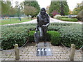
"The Airman", Kings Hill
Kings Hill was developed from 1969 on the site of the former RAF West Malling.
RAF West Malling had a long and distinguished history from the First World War, through the air shows of the 1930s and the Second World War when it was a front line airfield against the Luftwaffe. After the War, West Malling was in use throughout the 1950s and early 1960s as Britain's premier night fighter station before closure as an operational air station in 1969. A fuller history of West Malling Airfield can be seen at https://en.wikipedia.org/wiki/RAF_West_Malling
This statue at the end of Gibson Drive (doubtless named after Wing Commander Guy Gibson VC of Dambusters fame) is titled 'The Airman'. The inscription beneath says "THIS UNNAMED AIRMAN, A MEMBER OF AIRCREW DRESSED IN 1940S STYLE FLYING ATTIRE PORTRAYS A MEMBER OF EITHER ONE OF THE SHORT STAY SQUADRONS OR ONE OF THE MAIN STAY SQUADRONS, NAMELY Nos. 25, 29 AND 85 DURING THE WAR AND 500 SQUADRON WHICH WAS BASED HERE FROM 1946 - 1957."
Image: © Marathon
Taken: 13 Oct 2015
0.15 miles
2
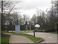
Roundabout at Kings Hill
At junction of Gibson Drive, Forest Way, and Kings Hill Avenue.
Image: © Oast House Archive
Taken: 26 Mar 2010
0.15 miles
3
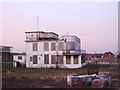
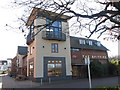
West Malling Airfield control tower, Kings Hill
Image: © Chris Whippet
Taken: 5 Mar 2010
0.17 miles
4
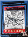
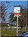
The Spitfire sign
Next to car park beside Alexander Grove.
Image
Image: © Oast House Archive
Taken: 23 Mar 2011
0.17 miles
5
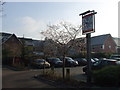
The Spitfire Pub Sign
On Alexander Grove. The roundabout in the background is on Alexander Grove, has access road to Pub car park and straight on to Asda Supermarket.
Image: © David Anstiss
Taken: 27 Jan 2009
0.18 miles
6
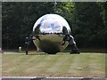
Sphere & Statues
An arresting sculpture just outside the entrance to Tonbridge & Malling County Council buildings in Kingshill, sited in the centre of a roundabout. It consists of a spectacularly reflecting sphere being "held up" by 3 people.
Image: © Hywel Williams
Taken: 9 Jul 2005
0.19 miles
8
The Spitfire public house, King's Hill
Image: © Stacey Harris
Taken: 13 Mar 2010
0.21 miles
9
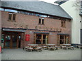
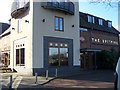
The Spitfire, King's Hill
A modern Shepherd Neame pub at 1 Liberty Square.
Image: © Oast House Archive
Taken: 23 Mar 2011
0.21 miles
10
The Spitfire Pub, King's Hill
In Liberty Square, part of the shopping centre.
Image: © David Anstiss
Taken: 27 Jan 2009
0.21 miles