IMAGES TAKEN NEAR TO
Tempest Road, WEST MALLING, ME19 4TY
Introduction
This page details the photographs taken nearby to Tempest Road, ME19 4TY by members of the Geograph project.
The Geograph project started in 2005 with the aim of publishing, organising and preserving representative images for every square kilometre of Great Britain, Ireland and the Isle of Man.

There are currently over 7.5m images from over14,400 individuals and you can help contribute to the project by visiting https://www.geograph.org.uk
Image Map
Images are licensed for reuse under creativecommons.org/licenses/by-sa/2.0
Notes
- Clicking on the map will re-center to the selected point.
- The higher the marker number, the further away the image location is from the centre of the postcode.
Image Listing (32 Images Found)
Images are licensed for reuse under creativecommons.org/licenses/by-sa/2.0
Image
Details
Distance
2
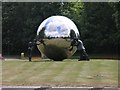
Sphere & Statues
An arresting sculpture just outside the entrance to Tonbridge & Malling County Council buildings in Kingshill, sited in the centre of a roundabout. It consists of a spectacularly reflecting sphere being "held up" by 3 people.
Image: © Hywel Williams
Taken: 9 Jul 2005
0.07 miles
3
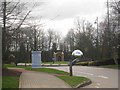
Roundabout at Kings Hill
At junction of Gibson Drive, Forest Way, and Kings Hill Avenue.
Image: © Oast House Archive
Taken: 26 Mar 2010
0.09 miles