IMAGES TAKEN NEAR TO
Melrose Avenue, WEST MALLING, ME19 4RS
Introduction
This page details the photographs taken nearby to Melrose Avenue, ME19 4RS by members of the Geograph project.
The Geograph project started in 2005 with the aim of publishing, organising and preserving representative images for every square kilometre of Great Britain, Ireland and the Isle of Man.

There are currently over 7.5m images from over14,400 individuals and you can help contribute to the project by visiting https://www.geograph.org.uk
Image Map
Images are licensed for reuse under creativecommons.org/licenses/by-sa/2.0
Notes
- Clicking on the map will re-center to the selected point.
- The higher the marker number, the further away the image location is from the centre of the postcode.
Image Listing (31 Images Found)
Images are licensed for reuse under creativecommons.org/licenses/by-sa/2.0
Image
Details
Distance
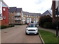
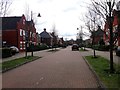
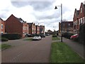
1
Discovery Drive
Modern Georgian style buildings in the Sprawl Kings Hill development.
Image: © Oast House Archive
Taken: 19 Jan 2011
0.04 miles

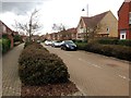
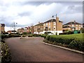
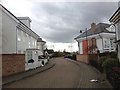
7
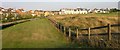
King's Hill Housing Estate
The edge of King's Hill, a new housing estate built on the ground that was originally occupied by West Malling airfield. King's Hill golf course can be seen to the right.
Image: © Hywel Williams
Taken: 2 Aug 2005
0.13 miles