IMAGES TAKEN NEAR TO
Ingle Place, WEST MALLING, ME19 4HN
Introduction
This page details the photographs taken nearby to Ingle Place, ME19 4HN by members of the Geograph project.
The Geograph project started in 2005 with the aim of publishing, organising and preserving representative images for every square kilometre of Great Britain, Ireland and the Isle of Man.

There are currently over 7.5m images from over14,400 individuals and you can help contribute to the project by visiting https://www.geograph.org.uk
Image Map
Images are licensed for reuse under creativecommons.org/licenses/by-sa/2.0
Notes
- Clicking on the map will re-center to the selected point.
- The higher the marker number, the further away the image location is from the centre of the postcode.
Image Listing (26 Images Found)
Images are licensed for reuse under creativecommons.org/licenses/by-sa/2.0
Image
Details
Distance
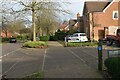
2
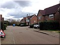
Townsend Square, Kings Hill
The name of the road, which isn't really a square in the traditional sense, but incorporates a small square area part of the way along it.
Image: © Robin Webster
Taken: 9 Jun 2012
0.09 miles
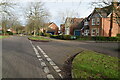
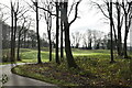
4
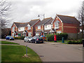
Bramley Way, Kings Hill
Houses overlooking a large oval shaped green. The centre piece of the sprawling Kings Hill development.
Image: © Oast House Archive
Taken: 26 Mar 2010
0.15 miles
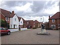
8
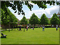
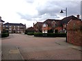
Playing on the green, Kings Hill
In one of the more established parts of the redeveloped West Malling airfield.
Image: © Robin Webster
Taken: 9 Jun 2012
0.16 miles