IMAGES TAKEN NEAR TO
Dawn Lane, WEST MALLING, ME19 4DH
Introduction
This page details the photographs taken nearby to Dawn Lane, ME19 4DH by members of the Geograph project.
The Geograph project started in 2005 with the aim of publishing, organising and preserving representative images for every square kilometre of Great Britain, Ireland and the Isle of Man.

There are currently over 7.5m images from over14,400 individuals and you can help contribute to the project by visiting https://www.geograph.org.uk
Image Map
Images are licensed for reuse under creativecommons.org/licenses/by-sa/2.0
Notes
- Clicking on the map will re-center to the selected point.
- The higher the marker number, the further away the image location is from the centre of the postcode.
Image Listing (31 Images Found)
Images are licensed for reuse under creativecommons.org/licenses/by-sa/2.0
Image
Details
Distance
1

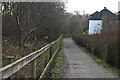
Derelict Airfield Building
This building has been derelict since the nearby airfield ceased its defence role in the Second World War. Outside, it doesn't look too remarkable but inside, there are still reminders of its WW2 use. On one of the walls (seen in the picture through the window) there's a painted area, where planes coming in and out of the airfield were recorded. Some of the pilot's names could still be faintly read chalked on the wall. In the back of the building there was an air raid bunker.
Image: © Hywel Williams
Taken: 10 Jul 2005
0.12 miles


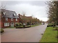
9
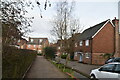
Path bordering the South East part of Kingshill houses
Image: © Ron Lee
Taken: 3 May 2016
0.15 miles