IMAGES TAKEN NEAR TO
Kings Hill Avenue, WEST MALLING, ME19 4AE
Introduction
This page details the photographs taken nearby to Kings Hill Avenue, ME19 4AE by members of the Geograph project.
The Geograph project started in 2005 with the aim of publishing, organising and preserving representative images for every square kilometre of Great Britain, Ireland and the Isle of Man.

There are currently over 7.5m images from over14,400 individuals and you can help contribute to the project by visiting https://www.geograph.org.uk
Image Map
Images are licensed for reuse under creativecommons.org/licenses/by-sa/2.0
Notes
- Clicking on the map will re-center to the selected point.
- The higher the marker number, the further away the image location is from the centre of the postcode.
Image Listing (5 Images Found)
Images are licensed for reuse under creativecommons.org/licenses/by-sa/2.0
Image
Details
Distance
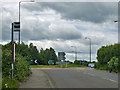
2
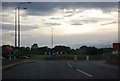
Roundabout at the end of the West Malling bypass
Image: © N Chadwick
Taken: 14 May 2011
0.22 miles
3
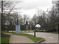
Roundabout at Kings Hill
At junction of Gibson Drive, Forest Way, and Kings Hill Avenue.
Image: © Oast House Archive
Taken: 26 Mar 2010
0.23 miles
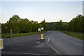
5
West Malling Kings Hill bus stop
On the old route through the village, just before the southern end of the bypass.
Image: © Robin Webster
Taken: 9 Jun 2012
0.25 miles