IMAGES TAKEN NEAR TO
Lees Road, MAIDSTONE, ME18 6HB
Introduction
This page details the photographs taken nearby to Lees Road, ME18 6HB by members of the Geograph project.
The Geograph project started in 2005 with the aim of publishing, organising and preserving representative images for every square kilometre of Great Britain, Ireland and the Isle of Man.

There are currently over 7.5m images from over14,400 individuals and you can help contribute to the project by visiting https://www.geograph.org.uk
Image Map
Images are licensed for reuse under creativecommons.org/licenses/by-sa/2.0
Notes
- Clicking on the map will re-center to the selected point.
- The higher the marker number, the further away the image location is from the centre of the postcode.
Image Listing (186 Images Found)
Images are licensed for reuse under creativecommons.org/licenses/by-sa/2.0
Image
Details
Distance
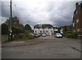
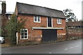
4
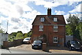
Vine House
Grade II listed. https://historicengland.org.uk/listing/the-list/list-entry/1069042
Image: © N Chadwick
Taken: 22 Aug 2020
0.02 miles
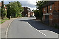
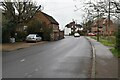
7
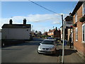
Looking east along Lees Road
There is a skip outside 1 Rose Cottage (on the right of the frame) almost overflowing with internal possessions that were ruined by the flooding that occurred, recently, along this road.
Image: © John Baker
Taken: 3 Feb 2014
0.02 miles