IMAGES TAKEN NEAR TO
Vicarage Road, MAIDSTONE, ME18 6DR
Introduction
This page details the photographs taken nearby to Vicarage Road, ME18 6DR by members of the Geograph project.
The Geograph project started in 2005 with the aim of publishing, organising and preserving representative images for every square kilometre of Great Britain, Ireland and the Isle of Man.

There are currently over 7.5m images from over14,400 individuals and you can help contribute to the project by visiting https://www.geograph.org.uk
Image Map
Images are licensed for reuse under creativecommons.org/licenses/by-sa/2.0
Notes
- Clicking on the map will re-center to the selected point.
- The higher the marker number, the further away the image location is from the centre of the postcode.
Image Listing (137 Images Found)
Images are licensed for reuse under creativecommons.org/licenses/by-sa/2.0
Image
Details
Distance
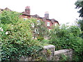
2
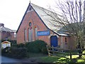
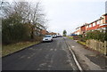
Yalding Baptist Church and Youth Centre
On Vicarage Road.
Image: © David Anstiss
Taken: 26 Jan 2009
0.05 miles
4
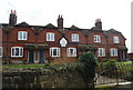
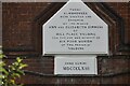
Almshouses, Yalding
Built in 1847 for the women of the village.
Image: © N Chadwick
Taken: 8 Feb 2009
0.06 miles
5

Yalding Primary School
Its full title is 'Yalding St Peter and St Paul Church of England Primary School'. It is quite large for a country school, extending to the left behind the trees for some way.
Image: © Robin Webster
Taken: 9 Jul 2012
0.06 miles
9
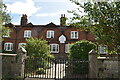
Almshouses, Yalding
Built in 1847 for six poor women of the village.
Image: © Chris Whippet
Taken: 13 Aug 2013
0.07 miles