IMAGES TAKEN NEAR TO
Gravelly Ways, MAIDSTONE, ME18 6DA
Introduction
This page details the photographs taken nearby to Gravelly Ways, ME18 6DA by members of the Geograph project.
The Geograph project started in 2005 with the aim of publishing, organising and preserving representative images for every square kilometre of Great Britain, Ireland and the Isle of Man.

There are currently over 7.5m images from over14,400 individuals and you can help contribute to the project by visiting https://www.geograph.org.uk
Image Map
Images are licensed for reuse under creativecommons.org/licenses/by-sa/2.0
Notes
- Clicking on the map will re-center to the selected point.
- The higher the marker number, the further away the image location is from the centre of the postcode.
Image Listing (39 Images Found)
Images are licensed for reuse under creativecommons.org/licenses/by-sa/2.0
Image
Details
Distance
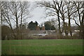
1
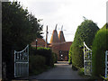
Woodfalls Oast, Woodfalls Farm, Laddingford, Kent
Image: © Oast House Archive
Taken: 3 Sep 2006
0.00 miles
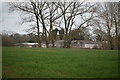
3
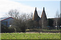
Woodfalls Oast, Woodfalls Farm, Laddingford
Image: © Oast House Archive
Taken: 1 Mar 2015
0.02 miles
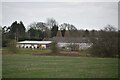
4
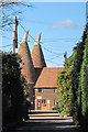
Woodfalls Oast, Woodfalls Farm, Laddingford
Image: © Oast House Archive
Taken: 1 Mar 2015
0.03 miles
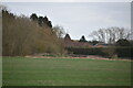
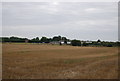
9
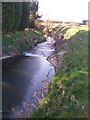
River Teise from Gravelly Ways Bridge
River winds through land to join River Medway at Yalding.
Image: © David Anstiss
Taken: 31 Mar 2009
0.06 miles
10
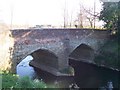
Gravelly Ways Bridge over River Teise
The road heads right to Beltring from Yalding.
Image: © David Anstiss
Taken: 31 Mar 2009
0.07 miles