IMAGES TAKEN NEAR TO
Claygate Road, MAIDSTONE, ME18 6BQ
Introduction
This page details the photographs taken nearby to Claygate Road, ME18 6BQ by members of the Geograph project.
The Geograph project started in 2005 with the aim of publishing, organising and preserving representative images for every square kilometre of Great Britain, Ireland and the Isle of Man.

There are currently over 7.5m images from over14,400 individuals and you can help contribute to the project by visiting https://www.geograph.org.uk
Image Map
Images are licensed for reuse under creativecommons.org/licenses/by-sa/2.0
Notes
- Clicking on the map will re-center to the selected point.
- The higher the marker number, the further away the image location is from the centre of the postcode.
Image Listing (13 Images Found)
Images are licensed for reuse under creativecommons.org/licenses/by-sa/2.0
Image
Details
Distance
4
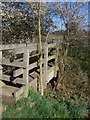
Ditch footbridge
On footpath from Claygate Road to Emmett Hill Lane.
Image: © David Anstiss
Taken: 31 Mar 2009
0.07 miles
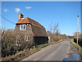
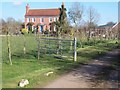
6
Duck Pond behind Peacock Farm cottages
Seen from footpath from Claygate Road to Emmett Hill Lane.
Image: © David Anstiss
Taken: 31 Mar 2009
0.16 miles
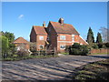
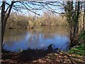
8
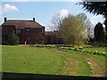
East Pikefish Farm
On access road from Claygate Road. Road also used by a bridleway to Pikefish Lane.
Image: © David Anstiss
Taken: 31 Mar 2009
0.23 miles