IMAGES TAKEN NEAR TO
Darman Lane, MAIDSTONE, ME18 6BL
Introduction
This page details the photographs taken nearby to Darman Lane, ME18 6BL by members of the Geograph project.
The Geograph project started in 2005 with the aim of publishing, organising and preserving representative images for every square kilometre of Great Britain, Ireland and the Isle of Man.

There are currently over 7.5m images from over14,400 individuals and you can help contribute to the project by visiting https://www.geograph.org.uk
Image Map
Images are licensed for reuse under creativecommons.org/licenses/by-sa/2.0
Notes
- Clicking on the map will re-center to the selected point.
- The higher the marker number, the further away the image location is from the centre of the postcode.
Image Listing (36 Images Found)
Images are licensed for reuse under creativecommons.org/licenses/by-sa/2.0
Image
Details
Distance
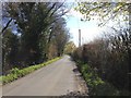
1
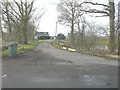
The entrance to Laddingford Farm
Seen from Darman Lane.
Image: © John Baker
Taken: 3 Feb 2014
0.01 miles
5
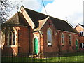
St Mary Church, Laddingford
This is a church, church hall & primary school all in one building
Image: © N Chadwick
Taken: 17 Feb 2006
0.07 miles
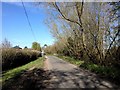
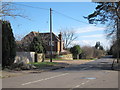
6
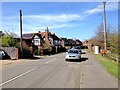
Looking north along Darman Lane
From near St Mary’s Church of England Primary School, Laddingford (part of which is seen on the right).
Image: © John Baker
Taken: 3 Feb 2014
0.11 miles

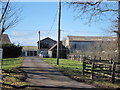
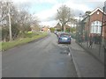
8
Claygate Road
A large three round kiln oast house once stood at what is now the entrance to St Mary's Close.
Image: © Oast House Archive
Taken: 1 Mar 2015
0.14 miles