IMAGES TAKEN NEAR TO
Old Road, MAIDSTONE, ME18 5PS
Introduction
This page details the photographs taken nearby to Old Road, ME18 5PS by members of the Geograph project.
The Geograph project started in 2005 with the aim of publishing, organising and preserving representative images for every square kilometre of Great Britain, Ireland and the Isle of Man.

There are currently over 7.5m images from over14,400 individuals and you can help contribute to the project by visiting https://www.geograph.org.uk
Image Map
Images are licensed for reuse under creativecommons.org/licenses/by-sa/2.0
Notes
- Clicking on the map will re-center to the selected point.
- The higher the marker number, the further away the image location is from the centre of the postcode.
Image Listing (41 Images Found)
Images are licensed for reuse under creativecommons.org/licenses/by-sa/2.0
Image
Details
Distance
1
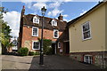
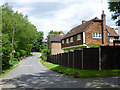
288 - 292, Old Rd
Grade II listed. https://historicengland.org.uk/listing/the-list/list-entry/1070655
Image: © N Chadwick
Taken: 5 Sep 2019
0.01 miles
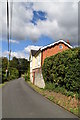
2
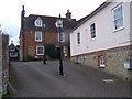
The Old Duke's Head Public House
This building with its interesting lighting in carpark was an old pub on Old Road. The pub sign can still be seen on the garage at the back of the building.
Image: © David Anstiss
Taken: 5 Mar 2009
0.01 miles
5
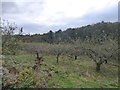
Old apple orchard
This old orchard has been fenced off and, as the apples were still on the trees in November, it is clear that the apples were no longer being harvested. This is the view from Old Road over a gate which had been wired off.
Image: © Marathon
Taken: 3 Nov 2019
0.03 miles
7
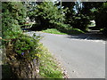
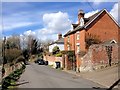
Pizien Well
This is Pizien Well Road in the hamlet of Pizien Well, to the west of Wateringbury. Old Road on the right leads to Wateringbury. The road crosses a stream here which forms the lakes in Mereworth Park and in due course meets the River Medway near Wateringbury Bridge.
Image: © Marathon
Taken: 7 Sep 2015
0.04 miles
8
Pizien Well
This is Pizien Well Road in the hamlet of Pizien Well to the west of Wateringbury. The road crosses a stream here which forms the lakes in Mereworth Park and in due course meets the River Medway near Wateringbury Bridge.
Image: © Marathon
Taken: 7 Sep 2015
0.06 miles
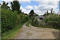
9
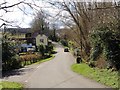
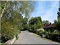
Pizien Well Road
The junction with Old Road is ahead on the right.
Image: © Robin Webster
Taken: 9 Jun 2012
0.06 miles