IMAGES TAKEN NEAR TO
Maidstone Road, MAIDSTONE, ME18 5HH
Introduction
This page details the photographs taken nearby to Maidstone Road, ME18 5HH by members of the Geograph project.
The Geograph project started in 2005 with the aim of publishing, organising and preserving representative images for every square kilometre of Great Britain, Ireland and the Isle of Man.

There are currently over 7.5m images from over14,400 individuals and you can help contribute to the project by visiting https://www.geograph.org.uk
Image Map
Images are licensed for reuse under creativecommons.org/licenses/by-sa/2.0
Notes
- Clicking on the map will re-center to the selected point.
- The higher the marker number, the further away the image location is from the centre of the postcode.
Image Listing (31 Images Found)
Images are licensed for reuse under creativecommons.org/licenses/by-sa/2.0
Image
Details
Distance
1
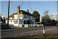
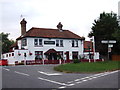
The Hop Pole, Nettlestead Green
On the B2015 opposite the turning for Yalding.
Image: © Robin Webster
Taken: 6 Feb 2007
0.03 miles
2
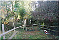
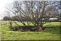
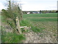
Stile on the Greensand Way, Nettlestead Green
Image: © N Chadwick
Taken: 2 Nov 2009
0.05 miles
3
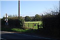
Stile on the Greensand Way, Nettlestead Green
Image: © N Chadwick
Taken: 2 Nov 2009
0.06 miles
9
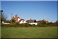
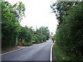
The Greensand Way approaching Nettlestead Green
The Greensand Way is a long distance path from Haslemere in Surrey to Ham Street on the edge of Romney Marsh. Here it is descending into the Medway Valley at Nettlestead Green.
Image: © Marathon
Taken: 17 Apr 2016
0.09 miles
10
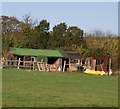
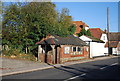
A couple of sheds near Nettlestead Green
Image: © N Chadwick
Taken: 2 Nov 2009
0.09 miles