IMAGES TAKEN NEAR TO
Maidstone Road, MAIDSTONE, ME18 5ET
Introduction
This page details the photographs taken nearby to Maidstone Road, ME18 5ET by members of the Geograph project.
The Geograph project started in 2005 with the aim of publishing, organising and preserving representative images for every square kilometre of Great Britain, Ireland and the Isle of Man.

There are currently over 7.5m images from over14,400 individuals and you can help contribute to the project by visiting https://www.geograph.org.uk
Image Map
Images are licensed for reuse under creativecommons.org/licenses/by-sa/2.0
Notes
- Clicking on the map will re-center to the selected point.
- The higher the marker number, the further away the image location is from the centre of the postcode.
Image Listing (101 Images Found)
Images are licensed for reuse under creativecommons.org/licenses/by-sa/2.0
Image
Details
Distance
2
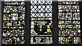
Nettlestead, St. Mary's Church: Medieval glass "Thomas a Becket returning from exile"
Thomas a Becket depicted with a number of monks is the central window
Image: © Michael Garlick
Taken: 15 Aug 2016
0.03 miles
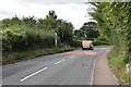
4
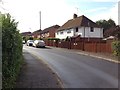
Honeys Oast, Maidstone Road, Nettlestead
Image: © Oast House Archive
Taken: 9 Jul 2017
0.05 miles
7
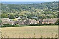
View over Nettlestead towards Bow Bridge
Boats in the marina near the bridge are visible near the centre of this scene.
Image: © David Martin
Taken: 1 Oct 2022
0.08 miles