IMAGES TAKEN NEAR TO
Bow Hill, MAIDSTONE, ME18 5EF
Introduction
This page details the photographs taken nearby to Bow Hill, ME18 5EF by members of the Geograph project.
The Geograph project started in 2005 with the aim of publishing, organising and preserving representative images for every square kilometre of Great Britain, Ireland and the Isle of Man.

There are currently over 7.5m images from over14,400 individuals and you can help contribute to the project by visiting https://www.geograph.org.uk
Image Map
Images are licensed for reuse under creativecommons.org/licenses/by-sa/2.0
Notes
- Clicking on the map will re-center to the selected point.
- The higher the marker number, the further away the image location is from the centre of the postcode.
Image Listing (168 Images Found)
Images are licensed for reuse under creativecommons.org/licenses/by-sa/2.0
Image
Details
Distance
2
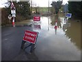
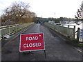
Road closed beyond Bow Bridge
There was a great deal of rain in the second half of December 2019 and the River Medway at Wateringbury was very high on 22nd December as can be seen at https://www.geograph.org.uk/photo/6352543 Bow Bridge could be crossed but in anticipation of the flooding here a notice of road closure was put in place beforereaching the bridge - see https://www.geograph.org.uk/photo/6352541 However, on Christmas Day 2013 the water was even higher as can be seen here where it covered Bow Bridge https://www.geograph.org.uk/photo/3789768
Image: © Marathon
Taken: 22 Dec 2019
0.02 miles
3
Road closed beyond Bow Bridge
There was a great deal of rain in the second half of December 2019 and the River Medway at Wateringbury was very high on 22nd December as can be seen at https://www.geograph.org.uk/photo/6352543 Bow Bridge could be crossed but in anticipation of the flooding here a notice of road closure was put in place beforereaching the bridge - see https://www.geograph.org.uk/photo/6352541 However, on Christmas Day 2013 the water was even higher as can be seen here where it covered Bow Bridge https://www.geograph.org.uk/photo/3789768
Image: © Marathon
Taken: 22 Dec 2019
0.03 miles
4
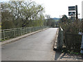
Bow Hill Bridge, Wateringbury
The bridge carries Bow Hill (unclassified road) over the River Medway.
Image: © Stephen Craven
Taken: 22 Mar 2009
0.04 miles
6
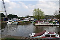
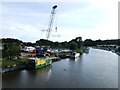
Wateringbury Marina
A small marina on the River Medway
Image: © N Chadwick
Taken: 13 Apr 2009
0.05 miles
7
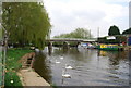
Swans on the River Medway at Wateringbury
This is the view from Bow Bridge in Wateringbury looking upstream. The swans were being fed by someone on the bank to the right and had all headed upriver to take advantage of this - see http://www.geograph.org.uk/photo/5690558
Image: © Marathon
Taken: 18 Feb 2018
0.05 miles
8
Road closed over Bow Bridge
There was a great deal of rain in the second half of December 2019 and the River Medway at Wateringbury was very high on 22nd December as can be seen at https://www.geograph.org.uk/photo/6352543 The reason for the closure was beyond the bridge as can be seen at https://www.geograph.org.uk/photo/6352573 However, on Christmas Day 2013 the water was even higher as can be seen here where it covered Bow Bridge https://www.geograph.org.uk/photo/3789768
Image: © Marathon
Taken: 22 Dec 2019
0.05 miles
9
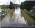
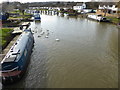
Bow Bridge at Wateringbury on Christmas Day
This is Bow Bridge in Wateringbury on Christmas Day. The River Medway has flooded its banks and has covered the road beyond the bridge so that Bow Hill is closed.
Image: © Marathon
Taken: 25 Dec 2013
0.06 miles