IMAGES TAKEN NEAR TO
Lockham Farm Avenue, MAIDSTONE, ME17 4TN
Introduction
This page details the photographs taken nearby to Lockham Farm Avenue, ME17 4TN by members of the Geograph project.
The Geograph project started in 2005 with the aim of publishing, organising and preserving representative images for every square kilometre of Great Britain, Ireland and the Isle of Man.

There are currently over 7.5m images from over14,400 individuals and you can help contribute to the project by visiting https://www.geograph.org.uk
Image Map
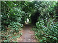
Images are licensed for reuse under creativecommons.org/licenses/by-sa/2.0
Notes
- Clicking on the map will re-center to the selected point.
- The higher the marker number, the further away the image location is from the centre of the postcode.
Image Listing (38 Images Found)
Images are licensed for reuse under creativecommons.org/licenses/by-sa/2.0
Image
Details
Distance

6
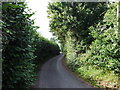
Pested Bars Road, near Boughton Monchelsea
Image: © Chris Whippet
Taken: 5 Aug 2013
0.10 miles
7
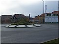
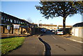
Roundabout on Brishing Road
Brishing Lane heads right to Cock Street. Brishing Road heading left leads to four wents. Seen from Brishing road, in Park Wood. Behind roundabout, Woodlands Housing Estate of Ward Homes.
Image: © David Anstiss
Taken: 20 Jan 2009
0.10 miles
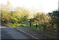
10
Pested Bars Road, near Boughton Monchelsea
Image: © Chris Whippet
Taken: 5 Aug 2013
0.11 miles