IMAGES TAKEN NEAR TO
Duke Of York Way, MAIDSTONE, ME17 4GT
Introduction
This page details the photographs taken nearby to Duke Of York Way, ME17 4GT by members of the Geograph project.
The Geograph project started in 2005 with the aim of publishing, organising and preserving representative images for every square kilometre of Great Britain, Ireland and the Isle of Man.

There are currently over 7.5m images from over14,400 individuals and you can help contribute to the project by visiting https://www.geograph.org.uk
Image Map
Images are licensed for reuse under creativecommons.org/licenses/by-sa/2.0
Notes
- Clicking on the map will re-center to the selected point.
- The higher the marker number, the further away the image location is from the centre of the postcode.
Image Listing (63 Images Found)
Images are licensed for reuse under creativecommons.org/licenses/by-sa/2.0
Image
Details
Distance

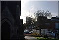
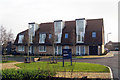
3
Water Tower in Avante Housing Estate
As seen from green of Church on Heath Road. The whole of this housing development site ( by Crest Nicholas) was hospital property ( Linton Hospital previously the Coxheath Union or Workhouse) including laundry, engineering workshops, garages for vehicles, Part III Accommodation under the 1948 Act, as well as acute wards linked to the West Kent General Hospital in Maidstone.
Image: © David Anstiss
Taken: 21 Jan 2009
0.05 miles
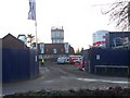
5
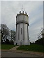
Water Tower at Coxheath
This tower can be seen for many miles around. It is on a ridge. There are numerous radio aerials on the top but I don't know what they are for.
Image: © Danny P Robinson
Taken: 4 May 2013
0.07 miles
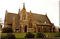
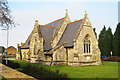
7
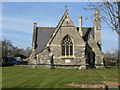
Holy Trinity Church, Coxheath
On a green on Heath Road. The land is on part of the 'Avante' Housing Estate, as seen in background, currently being built by Crest Nicholas. This Church is all that remains of the former Linton Hospital previously the Coxheath Union or Workhouse. A road nearby is named as 'Workhouse Lane'. When the Health Authority disposed of the hospital land upon the closure of the hospital. The church was made available for Anglican and Roman Catholic worship. In the diocese of Rochester. See http://en.wikipedia.org/wiki/Coxheath for more details on Coxheath.
Image: © David Anstiss
Taken: 21 Jan 2009
0.08 miles
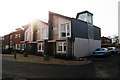
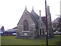
8
View of Holy Trinity church from the east
Image: © Nick Smith
Taken: 16 Mar 2010
0.08 miles