IMAGES TAKEN NEAR TO
Meridian Close, MAIDSTONE, ME17 4GP
Introduction
This page details the photographs taken nearby to Meridian Close, ME17 4GP by members of the Geograph project.
The Geograph project started in 2005 with the aim of publishing, organising and preserving representative images for every square kilometre of Great Britain, Ireland and the Isle of Man.

There are currently over 7.5m images from over14,400 individuals and you can help contribute to the project by visiting https://www.geograph.org.uk
Image Map
Images are licensed for reuse under creativecommons.org/licenses/by-sa/2.0
Notes
- Clicking on the map will re-center to the selected point.
- The higher the marker number, the further away the image location is from the centre of the postcode.
Image Listing (30 Images Found)
Images are licensed for reuse under creativecommons.org/licenses/by-sa/2.0
Image
Details
Distance
1
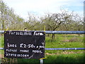
The Price of Fish
Logs advertised for sale on the barred metal gate outside an apple orchard.
Image: © Colin Smith
Taken: 26 Apr 2008
0.07 miles
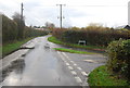
4
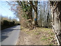
Workhouse Lane, Coxheath
Workhouse Lane takes its name from the old workhouse of the Coxheath Poor Law Union which was originally built in 1771 and lasted until 1838 when a new workhouse was built which lasted from 1828 until 1929 on the site of what later became Linton Hospital.
For more information see http://www.coxheath.net/?pageid=44 and http://archiver.rootsweb.ancestry.com/th/read/UK-WORKHOUSE-HOSP/2000-10/0971562334
Here, Hamlet Wood is ahead, beyond the bend.
Image: © Marathon
Taken: 12 Mar 2015
0.10 miles

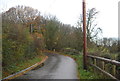
6
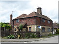
Firtree Cottage, Coxheath
Maps of the 19th century show Firtree Cottage in Forstal Lane as being quite isolated with the nearest village being at Loose. The growth of Coxheath in the 20th century means that the house is now very much on the edge of the village and surrounded by modern houses.
Image: © Marathon
Taken: 5 Jun 2017
0.11 miles
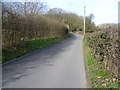
7
Workhouse Lane, Coxheath
Workhouse Lane takes its name from the old workhouse of the Coxheath Poor Law Union which was originally built in 1771 and lasted until 1838 when a new workhouse was built which lasted from 1828 until 1929 on the site of what later became Linton Hospital.
For more information see http://www.coxheath.net/?pageid=44 and http://archiver.rootsweb.ancestry.com/th/read/UK-WORKHOUSE-HOSP/2000-10/0971562334
Here, Hamlet Wood is on the right.
Image: © Marathon
Taken: 12 Mar 2015
0.11 miles
8
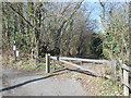
Entrance to Public Footpath off Workhouse Lane
At the other end of this path is Image]
Image: © Danny P Robinson
Taken: 4 Mar 2013
0.12 miles