IMAGES TAKEN NEAR TO
Heath Road, MAIDSTONE, ME17 4BG
Introduction
This page details the photographs taken nearby to Heath Road, ME17 4BG by members of the Geograph project.
The Geograph project started in 2005 with the aim of publishing, organising and preserving representative images for every square kilometre of Great Britain, Ireland and the Isle of Man.

There are currently over 7.5m images from over14,400 individuals and you can help contribute to the project by visiting https://www.geograph.org.uk
Image Map
Images are licensed for reuse under creativecommons.org/licenses/by-sa/2.0
Notes
- Clicking on the map will re-center to the selected point.
- The higher the marker number, the further away the image location is from the centre of the postcode.
Image Listing (64 Images Found)
Images are licensed for reuse under creativecommons.org/licenses/by-sa/2.0
Image
Details
Distance
2
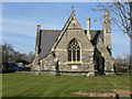
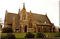
View of Holy Trinity church from the east
Image: © Nick Smith
Taken: 16 Mar 2010
0.03 miles
3
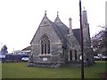
Holy Trinity Church, Coxheath
On a green on Heath Road. The land is on part of the 'Avante' Housing Estate, as seen in background, currently being built by Crest Nicholas. This Church is all that remains of the former Linton Hospital previously the Coxheath Union or Workhouse. A road nearby is named as 'Workhouse Lane'. When the Health Authority disposed of the hospital land upon the closure of the hospital. The church was made available for Anglican and Roman Catholic worship. In the diocese of Rochester. See http://en.wikipedia.org/wiki/Coxheath for more details on Coxheath.
Image: © David Anstiss
Taken: 21 Jan 2009
0.03 miles
5
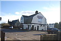
Spice Lounge
Former pub, converted to an Indian Restaurant.
Image: © N Chadwick
Taken: 27 Nov 2011
0.04 miles
6
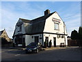
The Bell, Coxheath
Now trading as The Spice Lounge Indian restaurant.
Image: © Chris Whippet
Taken: 29 Aug 2013
0.04 miles

8
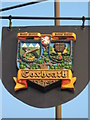
Coxheath Village Sign
This shield hangs off a millennium beacon on the B2163 Heath Road.
As seen in Image
The sign shows two shields. The left shield bears three tents above crossed guns. This is in reference to the fact that Coxheath was a military camp during the Seven Year War (see http://en.wikipedia.org/wiki/Seven_Years'_War for more details). Behind these military referenced shields is an apple tree (representing the fruit growing in the surrounding countryside). Linking the two shields is the badge of Invictia (the white horse of Kent). The Latin motto at the top of the sign reads 'Pagus Noster, Domus Nostra', this translates as 'Our Village, Our Home'.
The sign was designed by Bernard Hill, after a competition in 1971.
Image: © David Anstiss
Taken: 8 Oct 2010
0.05 miles
9
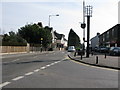
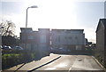
Junction of Westerhill Road with Heath Road, Coxheath
Image: © Nick Smith
Taken: 16 Mar 2010
0.05 miles