IMAGES TAKEN NEAR TO
Amber Lane, MAIDSTONE, ME17 3SE
Introduction
This page details the photographs taken nearby to Amber Lane, ME17 3SE by members of the Geograph project.
The Geograph project started in 2005 with the aim of publishing, organising and preserving representative images for every square kilometre of Great Britain, Ireland and the Isle of Man.

There are currently over 7.5m images from over14,400 individuals and you can help contribute to the project by visiting https://www.geograph.org.uk
Image Map
Images are licensed for reuse under creativecommons.org/licenses/by-sa/2.0
Notes
- Clicking on the map will re-center to the selected point.
- The higher the marker number, the further away the image location is from the centre of the postcode.
Image Listing (46 Images Found)
Images are licensed for reuse under creativecommons.org/licenses/by-sa/2.0
Image
Details
Distance
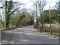
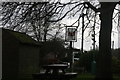
2
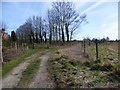
Track on the edge of Chart Sutton
The track leads off Amber Lane but is not a public footpath and just services the fields beyond.
Image: © Marathon
Taken: 12 Mar 2015
0.07 miles
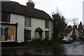
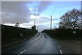
3
Amber Lane, Chart Sutton
This is towards the western edge of Chart Sutton.
Image: © Marathon
Taken: 12 Mar 2015
0.07 miles
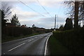
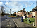
4
B2163, Plough Wents Rd
To Boughton Monchelsea.
Image: © N Chadwick
Taken: 25 Nov 2012
0.09 miles
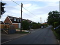
6
Lested Farm Oast, Plough Wents Road, Chart Sutton, Kent
Image: © Oast House Archive
Taken: 23 Sep 2007
0.11 miles
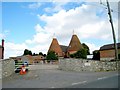
8

Lested Farm Oast, Plough Wents Road, Chart Sutton, Kent
Two round kiln oast house, converted to offices.
Image: © Oast House Archive
Taken: 17 Nov 2009
0.12 miles