IMAGES TAKEN NEAR TO
Amber Way, MAIDSTONE, ME17 3SD
Introduction
This page details the photographs taken nearby to Amber Way, ME17 3SD by members of the Geograph project.
The Geograph project started in 2005 with the aim of publishing, organising and preserving representative images for every square kilometre of Great Britain, Ireland and the Isle of Man.

There are currently over 7.5m images from over14,400 individuals and you can help contribute to the project by visiting https://www.geograph.org.uk
Image Map
Images are licensed for reuse under creativecommons.org/licenses/by-sa/2.0
Notes
- Clicking on the map will re-center to the selected point.
- The higher the marker number, the further away the image location is from the centre of the postcode.
Image Listing (43 Images Found)
Images are licensed for reuse under creativecommons.org/licenses/by-sa/2.0
Image
Details
Distance
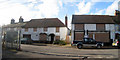
4
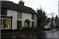
The Buffalo's Head, Chart Sutton
Former pub now known as the Lilypie cafe.
Image: © Chris Whippet
Taken: 30 Aug 2013
0.03 miles
6
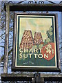
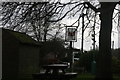
Close up of the village sign at Chart Sutton
Oast houses, hops and the prancing horse of Kent all feature. For the setting of the village sign see http://www.geograph.org.uk/photo/4383295
Image: © Marathon
Taken: 12 Mar 2015
0.03 miles
7
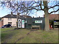
Shop on the Green, Chart Sutton
Possibly replacing Image
Image: © N Chadwick
Taken: 25 Nov 2012
0.03 miles
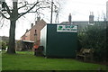
8
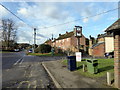
Boarded Up Buildings at Chart Corner
Two empty and boarded up buildings. The right building was formerly a convenience store and post office.
Image: © Oast House Archive
Taken: 17 Nov 2009
0.03 miles
9
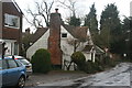
Grade II listed cottage
http://www.britishlistedbuildings.co.uk/en-174041-house-attached-to-north-of-post-office-s
Image: © N Chadwick
Taken: 25 Nov 2012
0.04 miles
10
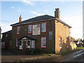
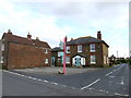
The Buffalo's Head, Chart Sutton
On Chart Hill Road.
Also see Image
Image: © Oast House Archive
Taken: 19 Nov 2010
0.04 miles