IMAGES TAKEN NEAR TO
Heath Road, MAIDSTONE, ME17 3LD
Introduction
This page details the photographs taken nearby to Heath Road, ME17 3LD by members of the Geograph project.
The Geograph project started in 2005 with the aim of publishing, organising and preserving representative images for every square kilometre of Great Britain, Ireland and the Isle of Man.

There are currently over 7.5m images from over14,400 individuals and you can help contribute to the project by visiting https://www.geograph.org.uk
Image Map
Images are licensed for reuse under creativecommons.org/licenses/by-sa/2.0
Notes
- Clicking on the map will re-center to the selected point.
- The higher the marker number, the further away the image location is from the centre of the postcode.
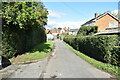
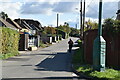
Image Listing (37 Images Found)
Images are licensed for reuse under creativecommons.org/licenses/by-sa/2.0
Image
Details
Distance
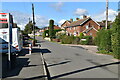
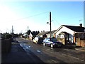
2

Langley Heath, Skinner's Way bus stop
Skinner's Way is the turning on the right just past the near hedge.
Image: © Robin Webster
Taken: 9 Jul 2012
0.03 miles
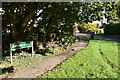
3
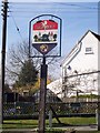
Langley Village Sign
At Porters Corner, on Green Lane. Green Lane joins Heath Road, opposite Porters Walk. Erected by the Parish Council. Made of painted metal. Shows a ring of friendship with the French fleur-de-lys and English rose, showing the twinship with the French community of Bray-sur-Somme.
Image: © David Anstiss
Taken: 18 Mar 2009
0.04 miles